Lunen geodata
Lunen (Soccsksargen) is a populated place; located in Philippines in Asia/Manila (GMT+8) time zone. With population of 2,416 people, there are 3437 cities with bigger population in this country. Compared to other cities in Philippines, 96.5% of cities are located further ↑North; 86.3% of cities are located further ←West and 87.3% of cities have lower elevation than Lunen. Note1


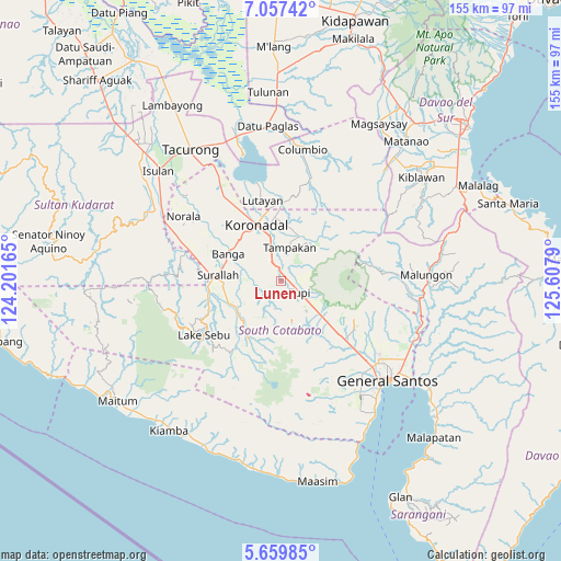
Lunen GPS coordinates[2]
6° 21' 32.796" North, 124° 54' 17.172" East
| Map corner | latitude | longitude |
|---|---|---|
| Upper-left | 7.05742°, | 124.20165° |
| Center: | 6.35911°, | 124.90477° |
| Lower-right: | 5.65985°, | 125.6079° |
| Map W x H: | 155.4×155.4 km | = 96.6×96.6mi |
| max Lat: | 20.78733° ⇑96.5% North |
| Lunen: | 6.35911° |
| min Lat: | ⇓3.5% South 4.65442° |
| min Long | Lunen | max Long |
| 117.04868° | 124.90477° | 126.58417° |
| W 86.3%⇐ | ⇒13.7% E |
Elevation
Elevation of Lunen is 172 m = 564 ft, and this is 84.1 m = 276 ft above average elevation for this country.
| Max E: |
2262 m = 7421 ft | 12.7% |
| Lunen | 172 m 564 ft | |
| Avg. | 87.9 m = 288 ft | |
Min E: |
-2 m = -7 ft | 87.3% |
See also: Philippines elevation on elevation.city.
Geographical zone
Lunen is located in North Torrid zone (between Equator and Tropic of Cancer). Distance of Equator is 707.1 km =439.4 mi to South.| Distance of | km | miles | from Lunen |
|---|---|---|---|
| North Pole | 9300 | 5778.8 | to North |
| Arctic Circle | 6694.1 | 4159.5 | to North |
| Tropic Cancer | 1898.9 | 1179.9 | to North |
| Equator | 707.1 | 439.4 | to South |


Nearby cities:
15 places around Lunen: (largest is in red/bold)
• Carpenter Hill
9.8 km =6.1 mi,  344°
344°
• Cebuano
7.7 km =4.8 mi,  65°
65°
• Kabalen
12.5 km =7.8 mi,  110°
110°
• Kipalbig
6.2 km =3.9 mi,  22°
22°
• Lamba
9.4 km =5.8 mi,  264°
264°
• Lambontong
11.8 km =7.3 mi,  241°
241°
• Lamian
8.5 km =5.3 mi,  229°
229°
• Lampari
5.8 km =3.6 mi,  207°
207°
• Liberty
13.7 km =8.5 mi,  38°
38°
• Linan
11.3 km =7 mi, 44°
• Maltana
7.9 km =4.9 mi,  26°
26°
• Palian
1.8 km =1.1 mi, 20°
• Polonoling
10.9 km =6.8 mi,  139°
139°
• Rotonda
14.9 km =9.3 mi,  352°
352°
• Tupi
6 km =3.7 mi,  117°
117°
Sources, notices
• [Note1] Compared only with cities in Philippines existing in our database
• [Src1] Map data: © OpenStreetMap contributors (CC-BY-SA)
• [Src2] Other city data from geonames.org with taken over terms of usage.
• [Src3] Geographical zone / Annual Mean Temperature by Robert A. Rohde @ Wikipedia
