Maltana geodata
Maltana (Soccsksargen) is a populated place; located in Philippines in Asia/Manila (GMT+8) time zone. With population of 3,361 people, there are 2176 cities with bigger population in this country. Compared to other cities in Philippines, 96.2% of cities are located further ↑North; 86.6% of cities are located further ←West and 86.2% of cities have lower elevation than Maltana. Note1
Administrative division(s):
- Level 1: Soccsksargen
- Level 2: Province of South Cotabato
- Level 3: Tampakan


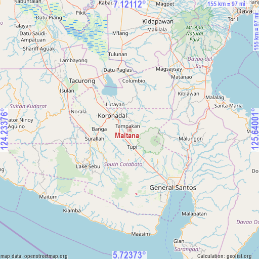
Maltana GPS coordinates[2]
6° 25' 22.44" North, 124° 56' 12.768" East
| Map corner | latitude | longitude |
|---|---|---|
| Upper-left | 7.12112°, | 124.23376° |
| Center: | 6.4229°, | 124.93688° |
| Lower-right: | 5.72373°, | 125.64001° |
| Map W x H: | 155.4×155.4 km | = 96.6×96.6mi |
| max Lat: | 20.78733° ⇑96.2% North |
| Maltana: | 6.4229° |
| min Lat: | ⇓3.8% South 4.65442° |
| min Long | Maltana | max Long |
| 117.04868° | 124.93688° | 126.58417° |
| W 86.6%⇐ | ⇒13.4% E |
Elevation
Elevation of Maltana is 153 m = 502 ft, and this is 65.1 m = 214 ft above average elevation for this country.
| Max E: |
2262 m = 7421 ft | 13.8% |
| Maltana | 153 m 502 ft | |
| Avg. | 87.9 m = 288 ft | |
Min E: |
-2 m = -7 ft | 86.2% |
See also: Philippines elevation on elevation.city.
Geographical zone
Maltana is located in North Torrid zone (between Equator and Tropic of Cancer). Distance of Equator is 714.2 km =443.8 mi to South.| Distance of | km | miles | from Maltana |
|---|---|---|---|
| North Pole | 9292.9 | 5774.3 | to North |
| Arctic Circle | 6687 | 4155.1 | to North |
| Tropic Cancer | 1891.8 | 1175.5 | to North |
| Equator | 714.2 | 443.8 | to South |


Nearby cities:
15 places around Maltana: (largest is in red/bold)
• Carpenter Hill
6.6 km =4.1 mi,  291°
291°
• Cebuano
5.2 km =3.2 mi,  138°
138°
• Kabalen
14.1 km =8.8 mi, 144°
• Kipalbig
1.8 km =1.1 mi,  220°
220°
• Koronadal
13.3 km =8.3 mi,  311°
311°
• Lamba
15.3 km =9.5 mi,  238°
238°
• Lampari
13.8 km =8.6 mi,  207°
207°
• Lampitak
12.8 km =8 mi,  85°
85°
• Liberty
6.2 km =3.9 mi,  54°
54°
• Linan
4.5 km =2.8 mi,  76°
76°
• Lunen
7.9 km =4.9 mi, 206°
• Mabini
9.7 km =6 mi,  340°
340°
• Palian
6.1 km =3.8 mi, 208°
• Rotonda
9.5 km =5.9 mi,  323°
323°
• Tupi
10 km =6.2 mi,  169°
169°
Sources, notices
• [Note1] Compared only with cities in Philippines existing in our database
• [Src1] Map data: © OpenStreetMap contributors (CC-BY-SA)
• [Src2] Other city data from geonames.org with taken over terms of usage.
• [Src3] Geographical zone / Annual Mean Temperature by Robert A. Rohde @ Wikipedia
