Palian geodata
Palian (Soccsksargen) is a populated place; located in Philippines in Asia/Manila (GMT+8) time zone. With population of 2,861 people, there are 2691 cities with bigger population in this country. Compared to other cities in Philippines, 96.4% of cities are located further ↑North; 86.4% of cities are located further ←West and 86.9% of cities have lower elevation than Palian. Note1


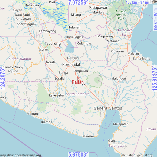
Palian GPS coordinates[2]
6° 22' 27.372" North, 124° 54' 38.232" East
| Map corner | latitude | longitude |
|---|---|---|
| Upper-left | 7.07256°, | 124.2075° |
| Center: | 6.37427°, | 124.91062° |
| Lower-right: | 5.67503°, | 125.61375° |
| Map W x H: | 155.4×155.4 km | = 96.6×96.6mi |
| max Lat: | 20.78733° ⇑96.4% North |
| Palian: | 6.37427° |
| min Lat: | ⇓3.6% South 4.65442° |
| min Long | Palian | max Long |
| 117.04868° | 124.91062° | 126.58417° |
| W 86.4%⇐ | ⇒13.6% E |
Elevation
Elevation of Palian is 165 m = 541 ft, and this is 77.1 m = 253 ft above average elevation for this country.
| Max E: |
2262 m = 7421 ft | 13.1% |
| Palian | 165 m 541 ft | |
| Avg. | 87.9 m = 288 ft | |
Min E: |
-2 m = -7 ft | 86.9% |
See also: Philippines elevation on elevation.city.
Geographical zone
Palian is located in North Torrid zone (between Equator and Tropic of Cancer). Distance of Equator is 708.8 km =440.4 mi to South.| Distance of | km | miles | from Palian |
|---|---|---|---|
| North Pole | 9298.3 | 5777.7 | to North |
| Arctic Circle | 6692.4 | 4158.5 | to North |
| Tropic Cancer | 1897.2 | 1178.9 | to North |
| Equator | 708.8 | 440.4 | to South |


Nearby cities:
15 places around Palian: (largest is in red/bold)
• Carpenter Hill
8.4 km =5.2 mi,  337°
337°
• Cebuano
6.6 km =4.1 mi,  76°
76°
• Kabalen
12.6 km =7.8 mi,  118°
118°
• Kipalbig
4.4 km =2.7 mi,  23°
23°
• Lamba
10.4 km =6.5 mi,  255°
255°
• Lambontong
13.3 km =8.3 mi,  236°
236°
• Lamian
10.1 km =6.3 mi,  224°
224°
• Lampari
7.6 km =4.7 mi,  206°
206°
• Liberty
12 km =7.5 mi,  41°
41°
• Linan
9.7 km =6 mi,  48°
48°
• Lunen
1.8 km =1.1 mi,  200°
200°
• Maltana
6.1 km =3.8 mi,  28°
28°
• Polonoling
11.8 km =7.3 mi,  147°
147°
• Rotonda
13.3 km =8.3 mi,  348°
348°
• Tupi
6.4 km =4 mi,  133°
133°
Sources, notices
• [Note1] Compared only with cities in Philippines existing in our database
• [Src1] Map data: © OpenStreetMap contributors (CC-BY-SA)
• [Src2] Other city data from geonames.org with taken over terms of usage.
• [Src3] Geographical zone / Annual Mean Temperature by Robert A. Rohde @ Wikipedia
