Polonoling geodata
Polonoling (Soccsksargen) is a populated place; located in Philippines in Asia/Manila (GMT+8) time zone. With population of 6,550 people, there are 958 cities with bigger population in this country. Compared to other cities in Philippines, 96.8% of cities are located further ↑North; 87.1% of cities are located further ←West and 94.1% of cities have lower elevation than Polonoling. Note1


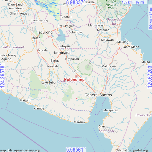
Polonoling GPS coordinates[2]
6° 17' 5.856" North, 124° 58' 8.04" East
| Map corner | latitude | longitude |
|---|---|---|
| Upper-left | 6.98337°, | 124.26578° |
| Center: | 6.28496°, | 124.9689° |
| Lower-right: | 5.58561°, | 125.67203° |
| Map W x H: | 155.4×155.4 km | = 96.6×96.6mi |
| max Lat: | 20.78733° ⇑96.8% North |
| Polonoling: | 6.28496° |
| min Lat: | ⇓3.2% South 4.65442° |
| min Long | Polonoling | max Long |
| 117.04868° | 124.9689° | 126.58417° |
| W 87.1%⇐ | ⇒12.9% E |
Elevation
Elevation of Polonoling is 377 m = 1237 ft, and this is 289.1 m = 948 ft above average elevation for this country.
| Max E: |
2262 m = 7421 ft | 5.9% |
| Polonoling | 377 m 1237 ft | |
| Avg. | 87.9 m = 288 ft | |
Min E: |
-2 m = -7 ft | 94.1% |
See also: Philippines elevation on elevation.city.
Geographical zone
Polonoling is located in North Torrid zone (between Equator and Tropic of Cancer). Distance of Equator is 698.8 km =434.2 mi to South.| Distance of | km | miles | from Polonoling |
|---|---|---|---|
| North Pole | 9308.2 | 5783.8 | to North |
| Arctic Circle | 6702.4 | 4164.7 | to North |
| Tropic Cancer | 1907.1 | 1185 | to North |
| Equator | 698.8 | 434.2 | to South |


Nearby cities:
15 places around Polonoling: (largest is in red/bold)
• Cebuano
11.5 km =7.1 mi,  359°
359°
• Kabalen
6 km =3.7 mi,  50°
50°
• Kipalbig
14.7 km =9.1 mi,  341°
341°
• Koronadal
4.9 km =3 mi,  155°
155°
• Lamian
13.8 km =8.6 mi,  281°
281°
• Lampari
10.3 km =6.4 mi,  287°
287°
• Lunen
10.9 km =6.8 mi,  319°
319°
• Maltana
15.7 km =9.8 mi,  347°
347°
• Pagalungan
5.4 km =3.4 mi,  113°
113°
• Palian
11.8 km =7.3 mi,  327°
327°
• Palkan
7.1 km =4.4 mi,  79°
79°
• Polo
16 km =9.9 mi,  98°
98°
• Polomolok
12.6 km =7.8 mi,  123°
123°
• Sulit
7.9 km =4.9 mi,  133°
133°
• Tupi
5.8 km =3.6 mi, 342°
Sources, notices
• [Note1] Compared only with cities in Philippines existing in our database
• [Src1] Map data: © OpenStreetMap contributors (CC-BY-SA)
• [Src2] Other city data from geonames.org with taken over terms of usage.
• [Src3] Geographical zone / Annual Mean Temperature by Robert A. Rohde @ Wikipedia
