Loon geodata
Loon (Central Visayas) is a seat of a third-order administrative division; located in Philippines in Asia/Manila (GMT+8) time zone. With population of 9,484 people, there are 652 cities with bigger population in this country. Compared to other cities in Philippines, 70.4% of cities are located further ↑North; 67.9% of cities are located further ←West and 51.1% of cities have lower elevation than Loon. Note1


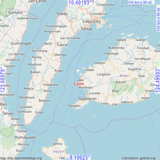
Loon GPS coordinates[2]
9° 47' 59.28" North, 123° 47' 34.44" East
| Map corner | latitude | longitude |
|---|---|---|
| Upper-left | 10.49193°, | 123.08978° |
| Center: | 9.7998°, | 123.7929° |
| Lower-right: | 9.10623°, | 124.49603° |
| Map W x H: | 154.1×154.1 km | = 95.8×95.8mi |
| max Lat: | 20.78733° ⇑70.4% North |
| Loon: | 9.7998° |
| min Lat: | ⇓29.6% South 4.65442° |
| min Long | Loon | max Long |
| 117.04868° | 123.7929° | 126.58417° |
| W 67.9%⇐ | ⇒32.1% E |
Elevation
Elevation of Loon is 24 m = 79 ft, and this is 63.9 m = 210 ft below average elevation for this country.
| Max E: |
2262 m = 7421 ft | 48.9% |
| Avg. | 87.9 m = 288 ft | |
| Loon | 24 m = 79 ft | |
Min E: |
-2 m = -7 ft | 51.1% |
See also: Philippines elevation on elevation.city.
Geographical zone
Loon is located in North Torrid zone (between Equator and Tropic of Cancer). Distance of Equator is 1089.6 km =677 mi to South.| Distance of | km | miles | from Loon |
|---|---|---|---|
| North Pole | 8917.4 | 5541 | to North |
| Arctic Circle | 6311.5 | 3921.8 | to North |
| Tropic Cancer | 1516.3 | 942.2 | to North |
| Equator | 1089.6 | 677 | to South |


Nearby cities:
15 places around Loon: (largest is in red/bold)
• Abucayan
19.6 km =12.2 mi,  42°
42°
• Antequera
11.8 km =7.3 mi,  100°
100°
• Bagacay
15.6 km =9.7 mi,  61°
61°
• Bood
7.2 km =4.5 mi,  147°
147°
• Calape
13.6 km =8.5 mi, 41°
• Corella
18.9 km =11.7 mi,  131°
131°
• Cortes
12.9 km =8 mi, 132°
• De la Paz
13.6 km =8.5 mi,  144°
144°
• Maribojoc
8.6 km =5.3 mi, 138°
• San Agustin
18.5 km =11.5 mi,  183°
183°
• San Isidro
16.3 km =10.1 mi, 37°
• Songculan
19.3 km =12 mi,  168°
168°
• Tabalong
19.9 km =12.4 mi, 173°
• Tagbilaran City
17.3 km =10.7 mi,  157°
157°
• Totolan
19.5 km =12.1 mi, 162°
Sources, notices
• [Note1] Compared only with cities in Philippines existing in our database
• [Src1] Map data: © OpenStreetMap contributors (CC-BY-SA)
• [Src2] Other city data from geonames.org with taken over terms of usage.
• [Src3] Geographical zone / Annual Mean Temperature by Robert A. Rohde @ Wikipedia
