Coron geodata
Coron (Mimaropa) is a seat of a third-order administrative division; located in Philippines in Asia/Manila (GMT+8) time zone. With population of 8,723 people, there are 709 cities with bigger population in this country. Compared to other cities in Philippines, 51.7% of cities are located further ↓South; 96% of cities are located further →East and 76.6% of cities have higher elevation than Coron. Note1


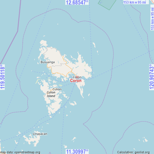
Coron GPS coordinates[2]
11° 59' 54.96" North, 120° 12' 15.48" East
| Map corner | latitude | longitude |
|---|---|---|
| Upper-left | 12.68547°, | 119.50118° |
| Center: | 11.9986°, | 120.2043° |
| Lower-right: | 11.30997°, | 120.90743° |
| Map W x H: | 152.9×152.9 km | = 95×95mi |
| max Lat: | 20.78733° ⇑48.3% North |
| Coron: | 11.9986° |
| min Lat: | ⇓51.7% South 4.65442° |
| min Long | Coron | max Long |
| 117.04868° | 120.2043° | 126.58417° |
| W 4%⇐ | ⇒96% E |
Elevation
Elevation of Coron is 10 m = 33 ft, and this is 77.9 m = 256 ft below average elevation for this country.
| Max E: |
2262 m = 7421 ft | 76.6% |
| Avg. | 87.9 m = 288 ft | |
| Coron | 10 m = 33 ft | |
Min E: |
-2 m = -7 ft | 23.4% |
See also: Philippines elevation on elevation.city.
Geographical zone
Coron is located in North Torrid zone (between Equator and Tropic of Cancer). Distance of this Northern Tropic circle is 1271.8 km =790.3 mi to North.| Distance of | km | miles | from Coron |
|---|---|---|---|
| North Pole | 8672.9 | 5389.1 | to North |
| Arctic Circle | 6067.1 | 3769.9 | to North |
| Tropic Cancer | 1271.8 | 790.3 | to North |
| Equator | 1334.1 | 829 | to South |


Nearby cities:
15 places around Coron: (largest is in red/bold)
• Adela
97 km =60.3 mi,  59°
59°
• Algeciras
93 km =57.8 mi,  134°
134°
• Babug
100.1 km =62.2 mi,  65°
65°
• Bagong Sikat
101.8 km =63.3 mi, 66°
• Bulalacao
28.6 km =17.8 mi,  187°
187°
• Buluang
44.2 km =27.5 mi,  306°
306°
• Busuanga
35.9 km =22.3 mi,  299°
299°
• Calintaan
101.3 km =62.9 mi,  51°
51°
• Panlaitan
40.9 km =25.4 mi,  289°
289°
• Rizal
97.8 km =60.8 mi, 57°
• Salvacion
33.1 km =20.6 mi, 296°
• San Agustin
97.3 km =60.5 mi, 61°
• San Jose
101.8 km =63.3 mi, 67°
• San Miguel
67 km =41.6 mi,  212°
212°
• San Pedro
101.6 km =63.1 mi, 59°
Sources, notices
• [Note1] Compared only with cities in Philippines existing in our database
• [Src1] Map data: © OpenStreetMap contributors (CC-BY-SA)
• [Src2] Other city data from geonames.org with taken over terms of usage.
• [Src3] Geographical zone / Annual Mean Temperature by Robert A. Rohde @ Wikipedia
