Adlay geodata
Adlay (Caraga) is a populated place; located in Philippines in Asia/Manila (GMT+8) time zone. With population of 2,548 people, there are 3213 cities with bigger population in this country. Compared to other cities in Philippines, 73.6% of cities are located further ↑North; 97.1% of cities are located further ←West and 80.7% of cities have higher elevation than Adlay. Note1


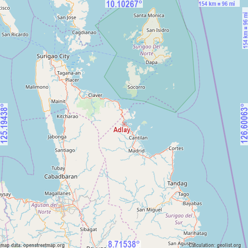
Adlay GPS coordinates[2]
9° 24' 34.992" North, 125° 53' 51" East
| Map corner | latitude | longitude |
|---|---|---|
| Upper-left | 10.10267°, | 125.19438° |
| Center: | 9.40972°, | 125.8975° |
| Lower-right: | 8.71538°, | 126.60063° |
| Map W x H: | 154.3×154.3 km | = 95.9×95.9mi |
| max Lat: | 20.78733° ⇑73.6% North |
| Adlay: | 9.40972° |
| min Lat: | ⇓26.4% South 4.65442° |
| min Long | Adlay | max Long |
| 117.04868° | 125.8975° | 126.58417° |
| W 97.1%⇐ | ⇒2.9% E |
Elevation
Elevation of Adlay is 9 m = 30 ft, and this is 78.9 m = 259 ft below average elevation for this country.
| Max E: |
2262 m = 7421 ft | 80.7% |
| Avg. | 87.9 m = 288 ft | |
| Adlay | 9 m = 30 ft | |
Min E: |
-2 m = -7 ft | 19.3% |
See also: Philippines elevation on elevation.city.
Geographical zone
Adlay is located in North Torrid zone (between Equator and Tropic of Cancer). Distance of Equator is 1046.3 km =650.1 mi to South.| Distance of | km | miles | from Adlay |
|---|---|---|---|
| North Pole | 8960.8 | 5568 | to North |
| Arctic Circle | 6354.9 | 3948.8 | to North |
| Tropic Cancer | 1559.7 | 969.2 | to North |
| Equator | 1046.3 | 650.1 | to South |


Nearby cities:
15 places around Adlay: (largest is in red/bold)
• Alegria
35.7 km =22.2 mi,  280°
280°
• Bacuag
35.9 km =22.3 mi,  307°
307°
• Burgos
35.7 km =22.2 mi,  116°
116°
• Cantilan
12.2 km =7.6 mi,  133°
133°
• Carmen
24.3 km =15.1 mi,  147°
147°
• Carrascal
7.2 km =4.5 mi, 127°
• Claver
25.6 km =15.9 mi,  315°
315°
• Cortes
35.3 km =21.9 mi,  114°
114°
• Gigaquit
30 km =18.6 mi, 313°
• Kitcharao
35.9 km =22.3 mi, 278°
• Lanuza
26.8 km =16.7 mi,  136°
136°
• Madrid
18 km =11.2 mi,  155°
155°
• Panikian
9.8 km =6.1 mi, 155°
• Parang
15.1 km =9.4 mi, 161°
• Socorro
24.7 km =15.3 mi,  17°
17°
Sources, notices
• [Note1] Compared only with cities in Philippines existing in our database
• [Src1] Map data: © OpenStreetMap contributors (CC-BY-SA)
• [Src2] Other city data from geonames.org with taken over terms of usage.
• [Src3] Geographical zone / Annual Mean Temperature by Robert A. Rohde @ Wikipedia
