Buenlag geodata
Buenlag (Central Luzon) is a populated place; located in Philippines in Asia/Manila (GMT+8) time zone. With population of 2,545 people, there are 3218 cities with bigger population in this country. Compared to other cities in Philippines, 83.1% of cities are located further ↓South; 88.8% of cities are located further →East and 55.6% of cities have lower elevation than Buenlag. Note1


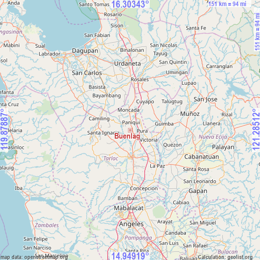
Buenlag GPS coordinates[2]
15° 37' 38.748" North, 120° 34' 55.164" East
| Map corner | latitude | longitude |
|---|---|---|
| Upper-left | 16.30343°, | 119.87887° |
| Center: | 15.62743°, | 120.58199° |
| Lower-right: | 14.94919°, | 121.28512° |
| Map W x H: | 150.6×150.6 km | = 93.6×93.6mi |
| max Lat: | 20.78733° ⇑16.9% North |
| Buenlag: | 15.62743° |
| min Lat: | ⇓83.1% South 4.65442° |
| min Long | Buenlag | max Long |
| 117.04868° | 120.58199° | 126.58417° |
| W 11.2%⇐ | ⇒88.8% E |
Elevation
Elevation of Buenlag is 28 m = 92 ft, and this is 59.9 m = 197 ft below average elevation for this country.
| Max E: |
2262 m = 7421 ft | 44.4% |
| Avg. | 87.9 m = 288 ft | |
| Buenlag | 28 m = 92 ft | |
Min E: |
-2 m = -7 ft | 55.6% |
See also: Philippines elevation on elevation.city.
Geographical zone
Buenlag is located in North Torrid zone (between Equator and Tropic of Cancer). Distance of this Northern Tropic circle is 868.3 km =539.5 mi to North.| Distance of | km | miles | from Buenlag |
|---|---|---|---|
| North Pole | 8269.5 | 5138.4 | to North |
| Arctic Circle | 5663.6 | 3519.2 | to North |
| Tropic Cancer | 868.3 | 539.5 | to North |
| Equator | 1737.6 | 1079.7 | to South |


Nearby cities:
15 places around Buenlag: (largest is in red/bold)
• Amacalan
6 km =3.7 mi,  148°
148°
• Balaoang
8.2 km =5.1 mi,  298°
298°
• Balite
6.7 km =4.2 mi,  73°
73°
• Bularit
7.8 km =4.8 mi, 147°
• Cabayaoasan
5.2 km =3.2 mi,  320°
320°
• Calayaan
9.9 km =6.2 mi,  227°
227°
• Cardona
6.2 km =3.9 mi,  172°
172°
• Estacion
8.5 km =5.3 mi,  19°
19°
• Estipona
7.3 km =4.5 mi,  124°
124°
• Gerona
2.9 km =1.8 mi,  143°
143°
• Nancamarinan
7.2 km =4.5 mi, 317°
• Pance
7.9 km =4.9 mi,  31°
31°
• Paniqui
4.6 km =2.9 mi,  358°
358°
• Pura
7.1 km =4.4 mi,  92°
92°
• Ramos
7.6 km =4.7 mi,  56°
56°
Sources, notices
• [Note1] Compared only with cities in Philippines existing in our database
• [Src1] Map data: © OpenStreetMap contributors (CC-BY-SA)
• [Src2] Other city data from geonames.org with taken over terms of usage.
• [Src3] Geographical zone / Annual Mean Temperature by Robert A. Rohde @ Wikipedia
