Calayaan geodata
Calayaan (Central Luzon) is a populated place; located in Philippines in Asia/Manila (GMT+8) time zone. With population of 2,285 people, there are 3712 cities with bigger population in this country. Compared to other cities in Philippines, 82.3% of cities are located further ↓South; 90.7% of cities are located further →East and 75.8% of cities have lower elevation than Calayaan. Note1


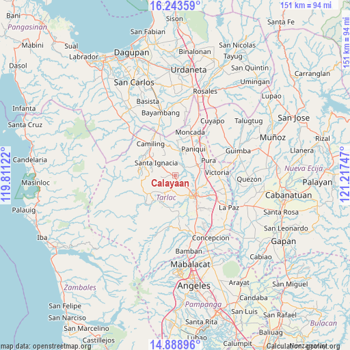
Calayaan GPS coordinates[2]
15° 34' 2.604" North, 120° 30' 51.624" East
| Map corner | latitude | longitude |
|---|---|---|
| Upper-left | 16.24359°, | 119.81122° |
| Center: | 15.56739°, | 120.51434° |
| Lower-right: | 14.88896°, | 121.21747° |
| Map W x H: | 150.6×150.6 km | = 93.6×93.6mi |
| max Lat: | 20.78733° ⇑17.7% North |
| Calayaan: | 15.56739° |
| min Lat: | ⇓82.3% South 4.65442° |
| min Long | Calayaan | max Long |
| 117.04868° | 120.51434° | 126.58417° |
| W 9.3%⇐ | ⇒90.7% E |
Elevation
Elevation of Calayaan is 71 m = 233 ft, and this is 16.9 m = 55 ft below average elevation for this country.
| Max E: |
2262 m = 7421 ft | 24.2% |
| Avg. | 87.9 m = 288 ft | |
| Calayaan | 71 m = 233 ft | |
Min E: |
-2 m = -7 ft | 75.8% |
See also: Philippines elevation on elevation.city.
Geographical zone
Calayaan is located in North Torrid zone (between Equator and Tropic of Cancer). Distance of this Northern Tropic circle is 875 km =543.7 mi to North.| Distance of | km | miles | from Calayaan |
|---|---|---|---|
| North Pole | 8276.1 | 5142.5 | to North |
| Arctic Circle | 5670.2 | 3523.3 | to North |
| Tropic Cancer | 875 | 543.7 | to North |
| Equator | 1730.9 | 1075.5 | to South |


Nearby cities:
15 places around Calayaan: (largest is in red/bold)
• Amacalan
10.5 km =6.5 mi,  81°
81°
• Balaoang
10.7 km =6.6 mi,  0°
0°
• Buenlag
9.9 km =6.2 mi,  47°
47°
• Cabayaoasan
11.4 km =7.1 mi,  20°
20°
• Cardona
8.1 km =5 mi,  86°
86°
• Gerona
9.9 km =6.2 mi,  64°
64°
• Mababanaba
9.7 km =6 mi,  216°
216°
• Nambalan
6.8 km =4.2 mi,  301°
301°
• Padapada
1.8 km =1.1 mi,  173°
173°
• San Francisco
10.8 km =6.7 mi,  309°
309°
• San Juan de Mata
4 km =2.5 mi,  154°
154°
• Santa Ignacia
10.1 km =6.3 mi, 303°
• Santa Ines West
5.5 km =3.4 mi,  257°
257°
• Sinait
8.3 km =5.2 mi,  114°
114°
• Vargas
4.1 km =2.5 mi, 314°
Sources, notices
• [Note1] Compared only with cities in Philippines existing in our database
• [Src1] Map data: © OpenStreetMap contributors (CC-BY-SA)
• [Src2] Other city data from geonames.org with taken over terms of usage.
• [Src3] Geographical zone / Annual Mean Temperature by Robert A. Rohde @ Wikipedia
