Alcala geodata
Alcala (Ilocos) is a seat of a third-order administrative division; located in Philippines in Asia/Manila (GMT+8) time zone. With population of 8,883 people, there are 698 cities with bigger population in this country. Compared to other cities in Philippines, 85.5% of cities are located further ↓South; 90.3% of cities are located further →East and 54.4% of cities have lower elevation than Alcala. Note1


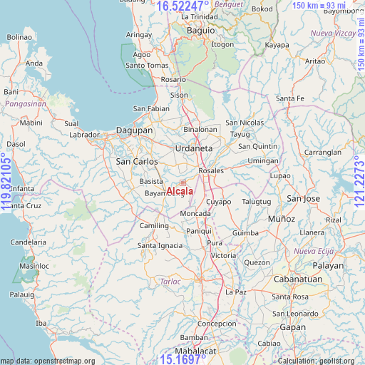
Alcala GPS coordinates[2]
15° 50' 49.992" North, 120° 31' 27.012" East
| Map corner | latitude | longitude |
|---|---|---|
| Upper-left | 16.52247°, | 119.82105° |
| Center: | 15.84722°, | 120.52417° |
| Lower-right: | 15.1697°, | 121.2273° |
| Map W x H: | 150.4×150.4 km | = 93.5×93.5mi |
| max Lat: | 20.78733° ⇑14.5% North |
| Alcala: | 15.84722° |
| min Lat: | ⇓85.5% South 4.65442° |
| min Long | Alcala | max Long |
| 117.04868° | 120.52417° | 126.58417° |
| W 9.7%⇐ | ⇒90.3% E |
Elevation
Elevation of Alcala is 27 m = 89 ft, and this is 60.9 m = 200 ft below average elevation for this country.
| Max E: |
2262 m = 7421 ft | 45.6% |
| Avg. | 87.9 m = 288 ft | |
| Alcala | 27 m = 89 ft | |
Min E: |
-2 m = -7 ft | 54.4% |
See also: Philippines elevation on elevation.city.
Geographical zone
Alcala is located in North Torrid zone (between Equator and Tropic of Cancer). Distance of this Northern Tropic circle is 843.9 km =524.4 mi to North.| Distance of | km | miles | from Alcala |
|---|---|---|---|
| North Pole | 8245 | 5123.2 | to North |
| Arctic Circle | 5639.1 | 3504 | to North |
| Tropic Cancer | 843.9 | 524.4 | to North |
| Equator | 1762 | 1094.9 | to South |


Nearby cities:
15 places around Alcala: (largest is in red/bold)
• Anulid
4.5 km =2.8 mi,  237°
237°
• Barangobong
4.3 km =2.7 mi,  37°
37°
• Bautista
7.6 km =4.7 mi,  201°
201°
• Buenlag
2.4 km =1.5 mi,  215°
215°
• Capulaan
6.6 km =4.1 mi,  12°
12°
• Nalsian Norte
7.8 km =4.8 mi,  268°
268°
• Olea
3.7 km =2.3 mi,  297°
297°
• Pindangan Centro
3.3 km =2.1 mi,  63°
63°
• Puelay
6.9 km =4.3 mi,  50°
50°
• Salcedo
8.2 km =5.1 mi,  82°
82°
• San Felipe
8.2 km =5.1 mi,  106°
106°
• San Pedro Apartado
4.5 km =2.8 mi,  104°
104°
• Sanlibo
8.2 km =5.1 mi,  19°
19°
• Unzad
8.1 km =5 mi, 11°
• Villanueva
5.9 km =3.7 mi,  156°
156°
Sources, notices
• [Note1] Compared only with cities in Philippines existing in our database
• [Src1] Map data: © OpenStreetMap contributors (CC-BY-SA)
• [Src2] Other city data from geonames.org with taken over terms of usage.
• [Src3] Geographical zone / Annual Mean Temperature by Robert A. Rohde @ Wikipedia
