Buenlag geodata
Buenlag (Ilocos) is a populated place; located in Philippines in Asia/Manila (GMT+8) time zone. With population of 2,302 people, there are 3679 cities with bigger population in this country. Compared to other cities in Philippines, 85.2% of cities are located further ↓South; 90.7% of cities are located further →East and 51.8% of cities have higher elevation than Buenlag. Note1


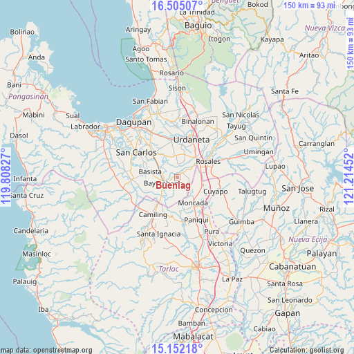
Buenlag GPS coordinates[2]
15° 49' 47.136" North, 120° 30' 41.004" East
| Map corner | latitude | longitude |
|---|---|---|
| Upper-left | 16.50507°, | 119.80827° |
| Center: | 15.82976°, | 120.51139° |
| Lower-right: | 15.15218°, | 121.21452° |
| Map W x H: | 150.4×150.4 km | = 93.5×93.5mi |
| max Lat: | 20.78733° ⇑14.8% North |
| Buenlag: | 15.82976° |
| min Lat: | ⇓85.2% South 4.65442° |
| min Long | Buenlag | max Long |
| 117.04868° | 120.51139° | 126.58417° |
| W 9.3%⇐ | ⇒90.7% E |
Elevation
Elevation of Buenlag is 22 m = 72 ft, and this is 65.9 m = 216 ft below average elevation for this country.
| Max E: |
2262 m = 7421 ft | 51.8% |
| Avg. | 87.9 m = 288 ft | |
| Buenlag | 22 m = 72 ft | |
Min E: |
-2 m = -7 ft | 48.2% |
See also: Philippines elevation on elevation.city.
Geographical zone
Buenlag is located in North Torrid zone (between Equator and Tropic of Cancer). Distance of this Northern Tropic circle is 845.8 km =525.6 mi to North.| Distance of | km | miles | from Buenlag |
|---|---|---|---|
| North Pole | 8247 | 5124.4 | to North |
| Arctic Circle | 5641.1 | 3505.2 | to North |
| Tropic Cancer | 845.8 | 525.6 | to North |
| Equator | 1760.1 | 1093.7 | to South |


Nearby cities:
15 places around Buenlag: (largest is in red/bold)
• Alcala
2.4 km =1.5 mi,  35°
35°
• Anulid
2.5 km =1.6 mi,  259°
259°
• Baluyot
6.6 km =4.1 mi,  235°
235°
• Barangobong
6.6 km =4.1 mi, 36°
• Bautista
5.3 km =3.3 mi,  195°
195°
• Bayambang
6.3 km =3.9 mi,  252°
252°
• Bical Norte
8.3 km =5.2 mi, 258°
• Capulaan
8.8 km =5.5 mi,  18°
18°
• Lepa
8.9 km =5.5 mi,  313°
313°
• Nalsian Norte
6.7 km =4.2 mi,  284°
284°
• Olea
4.1 km =2.5 mi,  332°
332°
• Pindangan Centro
5.5 km =3.4 mi,  51°
51°
• San Pedro Apartado
5.8 km =3.6 mi,  82°
82°
• Tococ East
9.1 km =5.7 mi,  266°
266°
• Villanueva
5.1 km =3.2 mi,  132°
132°
Sources, notices
• [Note1] Compared only with cities in Philippines existing in our database
• [Src1] Map data: © OpenStreetMap contributors (CC-BY-SA)
• [Src2] Other city data from geonames.org with taken over terms of usage.
• [Src3] Geographical zone / Annual Mean Temperature by Robert A. Rohde @ Wikipedia
