Nampicuan geodata
Nampicuan (Central Luzon) is a seat of a third-order administrative division; located in Philippines in Asia/Manila (GMT+8) time zone. With population of 6,058 people, there are 1035 cities with bigger population in this country. Compared to other cities in Philippines, 84.2% of cities are located further ↓South; 87.4% of cities are located further →East and 51.8% of cities have higher elevation than Nampicuan. Note1


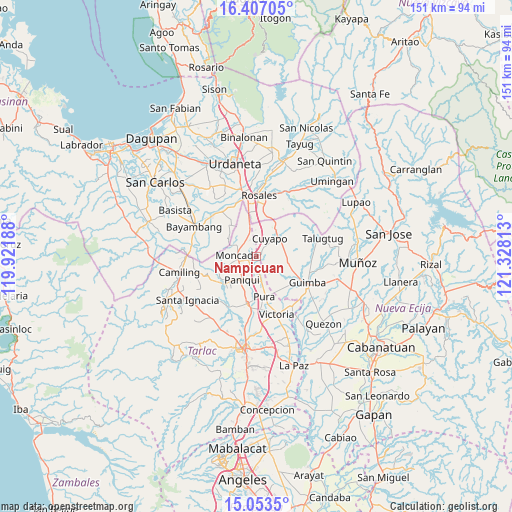
Nampicuan GPS coordinates[2]
15° 43' 53.04" North, 120° 37' 30" East
| Map corner | latitude | longitude |
|---|---|---|
| Upper-left | 16.40705°, | 119.92188° |
| Center: | 15.7314°, | 120.625° |
| Lower-right: | 15.0535°, | 121.32813° |
| Map W x H: | 150.5×150.5 km | = 93.5×93.5mi |
| max Lat: | 20.78733° ⇑15.8% North |
| Nampicuan: | 15.7314° |
| min Lat: | ⇓84.2% South 4.65442° |
| min Long | Nampicuan | max Long |
| 117.04868° | 120.625° | 126.58417° |
| W 12.6%⇐ | ⇒87.4% E |
Elevation
Elevation of Nampicuan is 22 m = 72 ft, and this is 65.9 m = 216 ft below average elevation for this country.
| Max E: |
2262 m = 7421 ft | 51.8% |
| Avg. | 87.9 m = 288 ft | |
| Nampicuan | 22 m = 72 ft | |
Min E: |
-2 m = -7 ft | 48.2% |
See also: Philippines elevation on elevation.city.
Geographical zone
Nampicuan is located in North Torrid zone (between Equator and Tropic of Cancer). Distance of this Northern Tropic circle is 856.8 km =532.4 mi to North.| Distance of | km | miles | from Nampicuan |
|---|---|---|---|
| North Pole | 8257.9 | 5131.2 | to North |
| Arctic Circle | 5652 | 3512 | to North |
| Tropic Cancer | 856.8 | 532.4 | to North |
| Equator | 1749.2 | 1086.9 | to South |


Nearby cities:
15 places around Nampicuan: (largest is in red/bold)
• Anao
0.3 km =0.2 mi,  172°
172°
• Balite
9.8 km =6.1 mi, 169°
• Baquero Norte
7.8 km =4.8 mi,  257°
257°
• Burgos
5.7 km =3.5 mi,  267°
267°
• Cabayaoasan
10.9 km =6.8 mi,  226°
226°
• Calancuasan Norte
8 km =5 mi,  12°
12°
• Cuyapo
7 km =4.3 mi,  37°
37°
• Estacion
4 km =2.5 mi,  206°
206°
• Lanat
7.1 km =4.4 mi,  342°
342°
• Moncada
5.5 km =3.4 mi, 274°
• Pance
4.8 km =3 mi,  186°
186°
• Paniqui
8.4 km =5.2 mi, 214°
• Ramos
7.5 km =4.7 mi, 167°
• San Felipe
10.9 km =6.8 mi, 344°
• San Manuel
7.7 km =4.8 mi,  346°
346°
Sources, notices
• [Note1] Compared only with cities in Philippines existing in our database
• [Src1] Map data: © OpenStreetMap contributors (CC-BY-SA)
• [Src2] Other city data from geonames.org with taken over terms of usage.
• [Src3] Geographical zone / Annual Mean Temperature by Robert A. Rohde @ Wikipedia
