Baler geodata
Baler (Central Luzon) is a seat of a third-order administrative division; located in Philippines in Asia/Manila (GMT+8) time zone. In our database, there are 4166 cities with bigger population. Compared to other cities in Philippines, 84.5% of cities are located further ↓South; 65.7% of cities are located further →East and 70.2% of cities have higher elevation than Baler. Note1


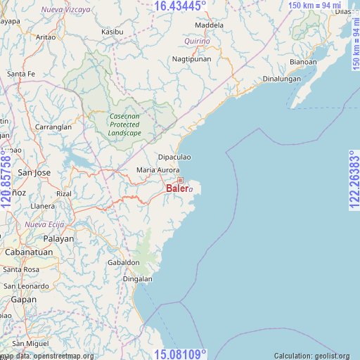
Baler GPS coordinates[2]
15° 45' 32.04" North, 121° 33' 38.52" East
| Map corner | latitude | longitude |
|---|---|---|
| Upper-left | 16.43445°, | 120.85758° |
| Center: | 15.7589°, | 121.5607° |
| Lower-right: | 15.08109°, | 122.26383° |
| Map W x H: | 150.5×150.5 km | = 93.5×93.5mi |
| max Lat: | 20.78733° ⇑15.5% North |
| Baler: | 15.7589° |
| min Lat: | ⇓84.5% South 4.65442° |
| min Long | Baler | max Long |
| 117.04868° | 121.5607° | 126.58417° |
| W 34.3%⇐ | ⇒65.7% E |
Elevation
Elevation of Baler is 12 m = 39 ft, and this is 75.9 m = 249 ft below average elevation for this country.
| Max E: |
2262 m = 7421 ft | 70.2% |
| Avg. | 87.9 m = 288 ft | |
| Baler | 12 m = 39 ft | |
Min E: |
-2 m = -7 ft | 29.8% |
See also: Philippines elevation on elevation.city.
Geographical zone
Baler is located in North Torrid zone (between Equator and Tropic of Cancer). Distance of this Northern Tropic circle is 853.7 km =530.5 mi to North.| Distance of | km | miles | from Baler |
|---|---|---|---|
| North Pole | 8254.8 | 5129.3 | to North |
| Arctic Circle | 5648.9 | 3510.1 | to North |
| Tropic Cancer | 853.7 | 530.5 | to North |
| Equator | 1752.2 | 1088.8 | to South |


Nearby cities:
15 places around Baler: (largest is in red/bold)
• Antipolo
42.7 km =26.5 mi,  248°
248°
• Bagong-Sikat
41.2 km =25.6 mi,  221°
221°
• Bongabon
46.7 km =29 mi, 252°
• Dingalan
44.8 km =27.8 mi,  203°
203°
• Gabaldon
41.6 km =25.8 mi,  214°
214°
• General Luna
41 km =25.5 mi,  265°
265°
• Laur
44.7 km =27.8 mi,  244°
244°
• Ligaya
40.4 km =25.1 mi,  226°
226°
• Macapsing
46.8 km =29.1 mi,  258°
258°
• Maria Aurora
10.2 km =6.3 mi,  294°
294°
• Pantabangan
44.9 km =27.9 mi,  277°
277°
• Sagana
48.6 km =30.2 mi, 244°
• San Luis
6 km =3.7 mi, 225°
• Siclong
41.1 km =25.5 mi, 241°
• Suklayin
1.1 km =0.7 mi, 261°
Sources, notices
• [Note1] Compared only with cities in Philippines existing in our database
• [Src1] Map data: © OpenStreetMap contributors (CC-BY-SA)
• [Src2] Other city data from geonames.org with taken over terms of usage.
• [Src3] Geographical zone / Annual Mean Temperature by Robert A. Rohde @ Wikipedia
