Bongabon geodata
Bongabon (Central Luzon) is a seat of a third-order administrative division; located in Philippines in Asia/Manila (GMT+8) time zone. With population of 36,168 people, there are 237 cities with bigger population in this country. Compared to other cities in Philippines, 83.1% of cities are located further ↓South; 72.6% of cities are located further →East and 76.6% of cities have lower elevation than Bongabon. Note1
Administrative division(s):
- Level 1: Central Luzon
- Level 2: Province of Nueva Ecija
- Level 3: Bongabon


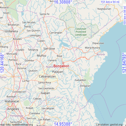
Bongabon GPS coordinates[2]
15° 37' 55.56" North, 121° 8' 41.28" East
| Map corner | latitude | longitude |
|---|---|---|
| Upper-left | 16.30808°, | 120.44168° |
| Center: | 15.6321°, | 121.1448° |
| Lower-right: | 14.95388°, | 121.84793° |
| Map W x H: | 150.6×150.6 km | = 93.6×93.6mi |
| max Lat: | 20.78733° ⇑16.9% North |
| Bongabon: | 15.6321° |
| min Lat: | ⇓83.1% South 4.65442° |
| min Long | Bongabon | max Long |
| 117.04868° | 121.1448° | 126.58417° |
| W 27.4%⇐ | ⇒72.6% E |
Elevation
Elevation of Bongabon is 74 m = 243 ft, and this is 13.9 m = 46 ft below average elevation for this country.
| Max E: |
2262 m = 7421 ft | 23.4% |
| Avg. | 87.9 m = 288 ft | |
| Bongabon | 74 m = 243 ft | |
Min E: |
-2 m = -7 ft | 76.6% |
See also: Philippines elevation on elevation.city.
Geographical zone
Bongabon is located in North Torrid zone (between Equator and Tropic of Cancer). Distance of this Northern Tropic circle is 867.8 km =539.2 mi to North.| Distance of | km | miles | from Bongabon |
|---|---|---|---|
| North Pole | 8268.9 | 5138.1 | to North |
| Arctic Circle | 5663 | 3518.8 | to North |
| Tropic Cancer | 867.8 | 539.2 | to North |
| Equator | 1738.1 | 1080 | to South |


Nearby cities:
15 places around Bongabon: (largest is in red/bold)
• Agbannawag
8.4 km =5.2 mi,  308°
308°
• Antipolo
5.1 km =3.2 mi,  107°
107°
• Bicos
11.5 km =7.1 mi,  285°
285°
• Del Pilar
9.4 km =5.8 mi,  318°
318°
• General Luna
11.6 km =7.2 mi,  18°
18°
• General Mamerto Natividad
10.5 km =6.5 mi,  251°
251°
• Laur
6.5 km =4 mi,  140°
140°
• Macapsing
5.3 km =3.3 mi,  344°
344°
• Paco Roman
6.8 km =4.2 mi,  296°
296°
• Palayan City
11.9 km =7.4 mi,  212°
212°
• Piñahan
8.9 km =5.5 mi,  266°
266°
• Rizal
9.8 km =6.1 mi,  334°
334°
• Sagana
7.1 km =4.4 mi,  173°
173°
• Sapang Buho
5.1 km =3.2 mi, 205°
• Siclong
10.2 km =6.3 mi,  123°
123°
Sources, notices
• [Note1] Compared only with cities in Philippines existing in our database
• [Src1] Map data: © OpenStreetMap contributors (CC-BY-SA)
• [Src2] Other city data from geonames.org with taken over terms of usage.
• [Src3] Geographical zone / Annual Mean Temperature by Robert A. Rohde @ Wikipedia
