General Luna geodata
General Luna (Central Luzon) is a populated place; located in Philippines in Asia/Manila (GMT+8) time zone. With population of 2,774 people, there are 2833 cities with bigger population in this country. Compared to other cities in Philippines, 84.2% of cities are located further ↓South; 72.1% of cities are located further →East and 88.2% of cities have lower elevation than General Luna. Note1
Administrative division(s):
- Level 1: Central Luzon
- Level 2: Province of Nueva Ecija
- Level 3: Pantabangan


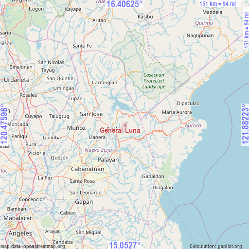
General Luna GPS coordinates[2]
15° 43' 50.16" North, 121° 10' 44.76" East
| Map corner | latitude | longitude |
|---|---|---|
| Upper-left | 16.40625°, | 120.47598° |
| Center: | 15.7306°, | 121.1791° |
| Lower-right: | 15.0527°, | 121.88223° |
| Map W x H: | 150.5×150.5 km | = 93.5×93.5mi |
| max Lat: | 20.78733° ⇑15.8% North |
| General Luna: | 15.7306° |
| min Lat: | ⇓84.2% South 4.65442° |
| min Long | General Luna | max Long |
| 117.04868° | 121.1791° | 126.58417° |
| W 27.9%⇐ | ⇒72.1% E |
Elevation
Elevation of General Luna is 185 m = 607 ft, and this is 97.1 m = 319 ft above average elevation for this country.
| Max E: |
2262 m = 7421 ft | 11.8% |
| General Luna | 185 m 607 ft | |
| Avg. | 87.9 m = 288 ft | |
Min E: |
-2 m = -7 ft | 88.2% |
See also: Philippines elevation on elevation.city.
Geographical zone
General Luna is located in North Torrid zone (between Equator and Tropic of Cancer). Distance of this Northern Tropic circle is 856.8 km =532.4 mi to North.| Distance of | km | miles | from General Luna |
|---|---|---|---|
| North Pole | 8258 | 5131.3 | to North |
| Arctic Circle | 5652.1 | 3512.1 | to North |
| Tropic Cancer | 856.8 | 532.4 | to North |
| Equator | 1749.1 | 1086.8 | to South |


Nearby cities:
15 places around General Luna: (largest is in red/bold)
• Agbannawag
11.7 km =7.3 mi,  240°
240°
• Antipolo
12.6 km =7.8 mi,  174°
174°
• Bicos
16.7 km =10.4 mi, 242°
• Bongabon
11.6 km =7.2 mi,  198°
198°
• Del Pilar
10.7 km =6.6 mi,  248°
248°
• Estrella
15.7 km =9.8 mi,  277°
277°
• Laur
16 km =9.9 mi,  178°
178°
• Macapsing
7.7 km =4.8 mi,  220°
220°
• Paco Roman
12.6 km =7.8 mi,  231°
231°
• Pantabangan
9.7 km =6 mi,  337°
337°
• Piñahan
17 km =10.6 mi, 227°
• Porais
14.8 km =9.2 mi, 280°
• Rizal
8.1 km =5 mi,  255°
255°
• Sapang Buho
16.6 km =10.3 mi, 200°
• Siclong
17.3 km =10.7 mi,  163°
163°
Sources, notices
• [Note1] Compared only with cities in Philippines existing in our database
• [Src1] Map data: © OpenStreetMap contributors (CC-BY-SA)
• [Src2] Other city data from geonames.org with taken over terms of usage.
• [Src3] Geographical zone / Annual Mean Temperature by Robert A. Rohde @ Wikipedia
