Mamonit geodata
Mamonit (Central Luzon) is a populated place; located in Philippines in Asia/Manila (GMT+8) time zone. With population of 2,178 people, there are 3928 cities with bigger population in this country. Compared to other cities in Philippines, 82.6% of cities are located further ↓South; 93.9% of cities are located further →East and 79.4% of cities have lower elevation than Mamonit. Note1


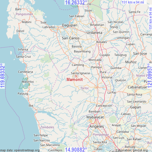
Mamonit GPS coordinates[2]
15° 35' 13.884" North, 120° 23' 47.184" East
| Map corner | latitude | longitude |
|---|---|---|
| Upper-left | 16.26332°, | 119.69332° |
| Center: | 15.58719°, | 120.39644° |
| Lower-right: | 14.90882°, | 121.09957° |
| Map W x H: | 150.6×150.6 km | = 93.6×93.6mi |
| max Lat: | 20.78733° ⇑17.4% North |
| Mamonit: | 15.58719° |
| min Lat: | ⇓82.6% South 4.65442° |
| min Long | Mamonit | max Long |
| 117.04868° | 120.39644° | 126.58417° |
| W 6.1%⇐ | ⇒93.9% E |
Elevation
Elevation of Mamonit is 88 m = 289 ft, and this is 0.099999999999994 m = 0 ft above average elevation for this country.
| Max E: |
2262 m = 7421 ft | 20.6% |
| Mamonit | 88 m 289 ft | |
| Avg. | 87.9 m = 288 ft | |
Min E: |
-2 m = -7 ft | 79.4% |
See also: Philippines elevation on elevation.city.
Geographical zone
Mamonit is located in North Torrid zone (between Equator and Tropic of Cancer). Distance of this Northern Tropic circle is 872.8 km =542.3 mi to North.| Distance of | km | miles | from Mamonit |
|---|---|---|---|
| North Pole | 8273.9 | 5141.2 | to North |
| Arctic Circle | 5668 | 3521.9 | to North |
| Tropic Cancer | 872.8 | 542.3 | to North |
| Equator | 1733.1 | 1076.9 | to South |


Nearby cities:
15 places around Mamonit: (largest is in red/bold)
• Bacsay
6.8 km =4.2 mi,  303°
303°
• Bamban
12 km =7.5 mi,  324°
324°
• Bobon Second
7.9 km =4.9 mi,  348°
348°
• Burgos
10.3 km =6.4 mi,  175°
175°
• Calayaan
12.8 km =8 mi,  99°
99°
• Camiling
11.2 km =7 mi,  9°
9°
• Mababanaba
12.1 km =7.5 mi,  145°
145°
• Malacampa
6.4 km =4 mi, 14°
• Mayantoc
4.2 km =2.6 mi,  330°
330°
• Nambalan
7 km =4.3 mi,  79°
79°
• San Francisco
6.3 km =3.9 mi,  42°
42°
• Santa Ignacia
5.4 km =3.4 mi,  51°
51°
• Santa Ines West
8 km =5 mi,  114°
114°
• Santa Maria
7 km =4.3 mi,  27°
27°
• Vargas
9.7 km =6 mi,  85°
85°
Sources, notices
• [Note1] Compared only with cities in Philippines existing in our database
• [Src1] Map data: © OpenStreetMap contributors (CC-BY-SA)
• [Src2] Other city data from geonames.org with taken over terms of usage.
• [Src3] Geographical zone / Annual Mean Temperature by Robert A. Rohde @ Wikipedia
