Santa Ignacia geodata
Santa Ignacia (Central Luzon) is a seat of a third-order administrative division; located in Philippines in Asia/Manila (GMT+8) time zone. With population of 11,477 people, there are 535 cities with bigger population in this country. Compared to other cities in Philippines, 82.9% of cities are located further ↓South; 92.6% of cities are located further →East and 66.4% of cities have lower elevation than Santa Ignacia. Note1
Administrative division(s):
- Level 1: Central Luzon
- Level 2: Province of Tarlac
- Level 3: Santa Ignacia


Santa Ignacia GPS coordinates[2]
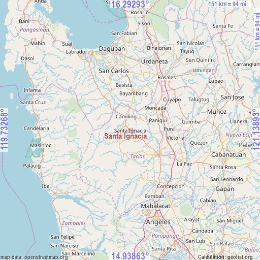
15° 37' 0.84" North, 120° 26' 8.88" East
| Map corner | latitude | longitude |
|---|---|---|
| Upper-left | 16.29293°, | 119.73268° |
| Center: | 15.6169°, | 120.4358° |
| Lower-right: | 14.93863°, | 121.13893° |
| Map W x H: | 150.6×150.6 km | = 93.6×93.6mi |
| max Lat: | 20.78733° ⇑17.1% North |
| Santa Ignacia: | 15.6169° |
| min Lat: | ⇓82.9% South 4.65442° |
| min Long | Santa Ignacia | max Long |
| 117.04868° | 120.4358° | 126.58417° |
| W 7.4%⇐ | ⇒92.6% E |
Elevation
Elevation of Santa Ignacia is 44 m = 144 ft, and this is 43.9 m = 144 ft below average elevation for this country.
| Max E: |
2262 m = 7421 ft | 33.6% |
| Avg. | 87.9 m = 288 ft | |
| Santa Ignacia | 44 m = 144 ft | |
Min E: |
-2 m = -7 ft | 66.4% |
See also: Philippines elevation on elevation.city.
Geographical zone
Santa Ignacia is located in North Torrid zone (between Equator and Tropic of Cancer). Distance of this Northern Tropic circle is 869.5 km =540.3 mi to North.| Distance of | km | miles | from Santa Ignacia |
|---|---|---|---|
| North Pole | 8270.6 | 5139.1 | to North |
| Arctic Circle | 5664.7 | 3519.9 | to North |
| Tropic Cancer | 869.5 | 540.3 | to North |
| Equator | 1736.4 | 1078.9 | to South |


Nearby cities:
15 places around Santa Ignacia: (largest is in red/bold)
• Bacsay
9.9 km =6.2 mi,  272°
272°
• Balaoang
9.9 km =6.2 mi,  58°
58°
• Bobon Second
7.3 km =4.5 mi,  307°
307°
• Calayaan
10.1 km =6.3 mi,  123°
123°
• Camiling
8.1 km =5 mi,  342°
342°
• Mabilang
8.6 km =5.3 mi,  41°
41°
• Malacampa
4 km =2.5 mi,  318°
318°
• Mamonit
5.4 km =3.4 mi,  231°
231°
• Mayantoc
6.3 km =3.9 mi, 273°
• Nambalan
3.3 km =2.1 mi,  127°
127°
• San Francisco
1.3 km =0.8 mi,  2°
2°
• Santa Ines West
7.3 km =4.5 mi,  155°
155°
• Santa Maria
3.1 km =1.9 mi, 341°
• Sinilian First
8.9 km =5.5 mi,  16°
16°
• Vargas
6.1 km =3.8 mi, 115°
Sources, notices
• [Note1] Compared only with cities in Philippines existing in our database
• [Src1] Map data: © OpenStreetMap contributors (CC-BY-SA)
• [Src2] Other city data from geonames.org with taken over terms of usage.
• [Src3] Geographical zone / Annual Mean Temperature by Robert A. Rohde @ Wikipedia
