Alicia geodata
Alicia (Cagayan Valley) is a seat of a third-order administrative division; located in Philippines in Asia/Manila (GMT+8) time zone. With population of 24,732 people, there are 323 cities with bigger population in this country. Compared to other cities in Philippines, 92.2% of cities are located further ↓South; 64.2% of cities are located further →East and 77% of cities have lower elevation than Alicia. Note1


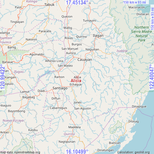
Alicia GPS coordinates[2]
16° 46' 45.696" North, 121° 41' 50.424" East
| Map corner | latitude | longitude |
|---|---|---|
| Upper-left | 17.45134°, | 120.99422° |
| Center: | 16.77936°, | 121.69734° |
| Lower-right: | 16.10499°, | 122.40047° |
| Map W x H: | 149.7×149.7 km | = 93×93mi |
| max Lat: | 20.78733° ⇑7.8% North |
| Alicia: | 16.77936° |
| min Lat: | ⇓92.2% South 4.65442° |
| min Long | Alicia | max Long |
| 117.04868° | 121.69734° | 126.58417° |
| W 35.8%⇐ | ⇒64.2% E |
Elevation
Elevation of Alicia is 75 m = 246 ft, and this is 12.9 m = 42 ft below average elevation for this country.
| Max E: |
2262 m = 7421 ft | 23% |
| Avg. | 87.9 m = 288 ft | |
| Alicia | 75 m = 246 ft | |
Min E: |
-2 m = -7 ft | 77% |
See also: Philippines elevation on elevation.city.
Geographical zone
Alicia is located in North Torrid zone (between Equator and Tropic of Cancer). Distance of this Northern Tropic circle is 740.2 km =459.9 mi to North.| Distance of | km | miles | from Alicia |
|---|---|---|---|
| North Pole | 8141.4 | 5058.8 | to North |
| Arctic Circle | 5535.5 | 3439.6 | to North |
| Tropic Cancer | 740.2 | 459.9 | to North |
| Equator | 1865.7 | 1159.3 | to South |


Nearby cities:
15 places around Alicia: (largest is in red/bold)
• Angadanan
6.1 km =3.8 mi,  116°
116°
• Batal
14.5 km =9 mi,  225°
225°
• Burgos
6.3 km =3.9 mi,  37°
37°
• Echague
8.6 km =5.3 mi,  195°
195°
• Gappal
14.7 km =9.1 mi,  64°
64°
• La Paz
14.9 km =9.3 mi,  348°
348°
• Malasin
9.7 km =6 mi,  73°
73°
• Nagrumbuan
13.4 km =8.3 mi,  5°
5°
• Pinoma
10.6 km =6.6 mi, 5°
• Ramos West
12.7 km =7.9 mi,  224°
224°
• Salinungan Proper
13.3 km =8.3 mi,  318°
318°
• San Guillermo
13.4 km =8.3 mi, 116°
• San Isidro
10 km =6.2 mi,  239°
239°
• Sillawit
12.3 km =7.6 mi,  32°
32°
• Soyung
9.4 km =5.8 mi, 201°
Sources, notices
• [Note1] Compared only with cities in Philippines existing in our database
• [Src1] Map data: © OpenStreetMap contributors (CC-BY-SA)
• [Src2] Other city data from geonames.org with taken over terms of usage.
• [Src3] Geographical zone / Annual Mean Temperature by Robert A. Rohde @ Wikipedia
