Alayao geodata
Alayao (Bicol) is a populated place; located in Philippines in Asia/Manila (GMT+8) time zone. With population of 2,406 people, there are 3447 cities with bigger population in this country. Compared to other cities in Philippines, 72.7% of cities are located further ↓South; 53.7% of cities are located further →East and 97.1% of cities have higher elevation than Alayao. Note1


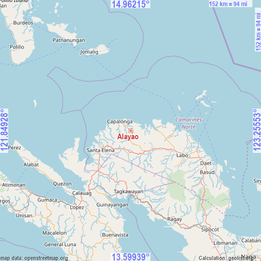
Alayao GPS coordinates[2]
14° 16' 54.48" North, 122° 33' 8.64" East
| Map corner | latitude | longitude |
|---|---|---|
| Upper-left | 14.96215°, | 121.84928° |
| Center: | 14.2818°, | 122.5524° |
| Lower-right: | 13.59939°, | 123.25553° |
| Map W x H: | 151.5×151.5 km | = 94.1×94.1mi |
| max Lat: | 20.78733° ⇑27.3% North |
| Alayao: | 14.2818° |
| min Lat: | ⇓72.7% South 4.65442° |
| min Long | Alayao | max Long |
| 117.04868° | 122.5524° | 126.58417° |
| W 46.3%⇐ | ⇒53.7% E |
Elevation
Elevation of Alayao is 4 m = 13 ft, and this is 83.9 m = 275 ft below average elevation for this country.
| Max E: |
2262 m = 7421 ft | 97.1% |
| Avg. | 87.9 m = 288 ft | |
| Alayao | 4 m = 13 ft | |
Min E: |
-2 m = -7 ft | 2.9% |
See also: Philippines elevation on elevation.city.
Geographical zone
Alayao is located in North Torrid zone (between Equator and Tropic of Cancer). Distance of this Northern Tropic circle is 1017.9 km =632.5 mi to North.| Distance of | km | miles | from Alayao |
|---|---|---|---|
| North Pole | 8419.1 | 5231.4 | to North |
| Arctic Circle | 5813.2 | 3612.2 | to North |
| Tropic Cancer | 1017.9 | 632.5 | to North |
| Equator | 1588 | 986.7 | to South |


Nearby cities:
15 places around Alayao: (largest is in red/bold)
• Banocboc
3.9 km =2.4 mi,  58°
58°
• Batobalane
22 km =13.7 mi,  104°
104°
• Calabaca
13 km =8.1 mi,  279°
279°
• Capalonga
8.3 km =5.2 mi,  310°
310°
• Daguit
21.4 km =13.3 mi,  118°
118°
• Gumaus
18.6 km =11.6 mi,  80°
80°
• Jose Pañganiban
15 km =9.3 mi,  86°
86°
• Larap
10.7 km =6.6 mi, 79°
• Luklukan
17.9 km =11.1 mi,  74°
74°
• Malatap
11.4 km =7.1 mi,  202°
202°
• Palali
7.7 km =4.8 mi,  290°
290°
• Santa Elena
22.1 km =13.7 mi,  235°
235°
• Santa Rosa Sur
18.6 km =11.6 mi, 97°
• Tigbinan
13.9 km =8.6 mi,  220°
220°
• Tugos
21.4 km =13.3 mi, 94°
Sources, notices
• [Note1] Compared only with cities in Philippines existing in our database
• [Src1] Map data: © OpenStreetMap contributors (CC-BY-SA)
• [Src2] Other city data from geonames.org with taken over terms of usage.
• [Src3] Geographical zone / Annual Mean Temperature by Robert A. Rohde @ Wikipedia
