Nuyo geodata
Nuyo (Autonomous Region in Muslim Mindanao) is a populated place; located in Philippines in Asia/Manila (GMT+8) time zone. With population of 2,224 people, there are 3839 cities with bigger population in this country. Compared to other cities in Philippines, 87.7% of cities are located further ↑North; 77.7% of cities are located further ←West and 84.5% of cities have lower elevation than Nuyo. Note1
Administrative division(s):
- Level 1: Autonomous Region in Muslim Mindanao
- Level 2: Province of Maguindanao
- Level 3: Buldon


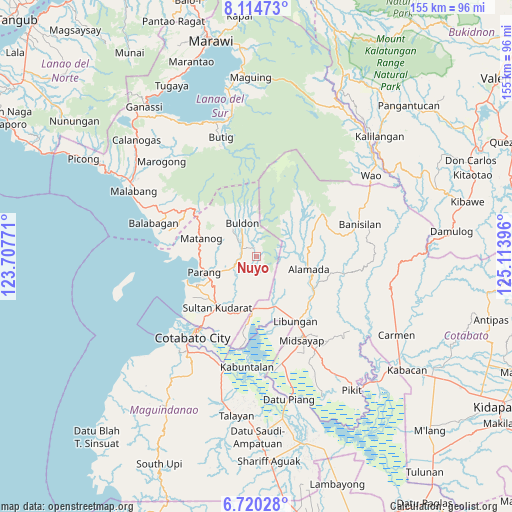
Nuyo GPS coordinates[2]
7° 25' 5.016" North, 124° 24' 38.988" East
| Map corner | latitude | longitude |
|---|---|---|
| Upper-left | 8.11473°, | 123.70771° |
| Center: | 7.41806°, | 124.41083° |
| Lower-right: | 6.72028°, | 125.11396° |
| Map W x H: | 155×155.1 km | = 96.3×96.4mi |
| max Lat: | 20.78733° ⇑87.7% North |
| Nuyo: | 7.41806° |
| min Lat: | ⇓12.3% South 4.65442° |
| min Long | Nuyo | max Long |
| 117.04868° | 124.41083° | 126.58417° |
| W 77.7%⇐ | ⇒22.3% E |
Elevation
Elevation of Nuyo is 129 m = 423 ft, and this is 41.1 m = 135 ft above average elevation for this country.
| Max E: |
2262 m = 7421 ft | 15.5% |
| Nuyo | 129 m 423 ft | |
| Avg. | 87.9 m = 288 ft | |
Min E: |
-2 m = -7 ft | 84.5% |
See also: Philippines elevation on elevation.city.
Geographical zone
Nuyo is located in North Torrid zone (between Equator and Tropic of Cancer). Distance of Equator is 824.8 km =512.5 mi to South.| Distance of | km | miles | from Nuyo |
|---|---|---|---|
| North Pole | 9182.3 | 5705.6 | to North |
| Arctic Circle | 6576.4 | 4086.4 | to North |
| Tropic Cancer | 1781.1 | 1106.7 | to North |
| Equator | 824.8 | 512.5 | to South |


Nearby cities:
15 places around Nuyo: (largest is in red/bold)
• Balogo
16.2 km =10.1 mi,  158°
158°
• Barira
14.5 km =9 mi,  301°
301°
• Bualan
16.1 km =10 mi,  281°
281°
• Bugasan
16.9 km =10.5 mi, 278°
• Buldon
11.1 km =6.9 mi,  336°
336°
• Dinganen
10.6 km =6.6 mi,  199°
199°
• Ebcor Town
2.9 km =1.8 mi,  329°
329°
• Kulempang
11.5 km =7.1 mi,  348°
348°
• Manuangan
15.7 km =9.8 mi,  182°
182°
• Mataya
7.3 km =4.5 mi,  323°
323°
• Parang
16.4 km =10.2 mi,  251°
251°
• Pigcawayan
15.7 km =9.8 mi,  174°
174°
• Rominimbang
15.2 km =9.4 mi,  306°
306°
• Sapadun
19.2 km =11.9 mi,  292°
292°
• Simuay
19.4 km =12.1 mi,  216°
216°
Sources, notices
• [Note1] Compared only with cities in Philippines existing in our database
• [Src1] Map data: © OpenStreetMap contributors (CC-BY-SA)
• [Src2] Other city data from geonames.org with taken over terms of usage.
• [Src3] Geographical zone / Annual Mean Temperature by Robert A. Rohde @ Wikipedia
