Dinganen geodata
Dinganen (Autonomous Region in Muslim Mindanao) is a populated place; located in Philippines in Asia/Manila (GMT+8) time zone. With population of 4,623 people, there are 1436 cities with bigger population in this country. Compared to other cities in Philippines, 88.3% of cities are located further ↑North; 77% of cities are located further ←West and 84.9% of cities have lower elevation than Dinganen. Note1
Administrative division(s):
- Level 1: Autonomous Region in Muslim Mindanao
- Level 2: Province of Maguindanao
- Level 3: Sultan Kudarat (Nuling)


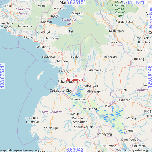
Dinganen GPS coordinates[2]
7° 19' 41.988" North, 124° 22' 41.988" East
| Map corner | latitude | longitude |
|---|---|---|
| Upper-left | 8.02515°, | 123.67521° |
| Center: | 7.32833°, | 124.37833° |
| Lower-right: | 6.63042°, | 125.08146° |
| Map W x H: | 155.1×155.1 km | = 96.4×96.4mi |
| max Lat: | 20.78733° ⇑88.3% North |
| Dinganen: | 7.32833° |
| min Lat: | ⇓11.7% South 4.65442° |
| min Long | Dinganen | max Long |
| 117.04868° | 124.37833° | 126.58417° |
| W 77%⇐ | ⇒23% E |
Elevation
Elevation of Dinganen is 136 m = 446 ft, and this is 48.1 m = 158 ft above average elevation for this country.
| Max E: |
2262 m = 7421 ft | 15.1% |
| Dinganen | 136 m 446 ft | |
| Avg. | 87.9 m = 288 ft | |
Min E: |
-2 m = -7 ft | 84.9% |
See also: Philippines elevation on elevation.city.
Geographical zone
Dinganen is located in North Torrid zone (between Equator and Tropic of Cancer). Distance of Equator is 814.8 km =506.3 mi to South.| Distance of | km | miles | from Dinganen |
|---|---|---|---|
| North Pole | 9192.2 | 5711.8 | to North |
| Arctic Circle | 6586.3 | 4092.5 | to North |
| Tropic Cancer | 1791.1 | 1112.9 | to North |
| Equator | 814.8 | 506.3 | to South |


Nearby cities:
15 places around Dinganen: (largest is in red/bold)
• Baguer
16 km =9.9 mi,  120°
120°
• Baka
13.9 km =8.6 mi,  245°
245°
• Balogo
10.7 km =6.6 mi, 118°
• Budta
15.4 km =9.6 mi,  153°
153°
• Dalumangcob
15.1 km =9.4 mi,  214°
214°
• Ebcor Town
12.7 km =7.9 mi,  9°
9°
• Gang
15.4 km =9.6 mi,  233°
233°
• Manuangan
6.4 km =4 mi, 153°
• Mataya
15.9 km =9.9 mi,  357°
357°
• Nuyo
10.6 km =6.6 mi,  19°
19°
• Parang
12.9 km =8 mi,  291°
291°
• Pigcawayan
7.7 km =4.8 mi,  137°
137°
• Pinaring
13.3 km =8.3 mi, 214°
• Simuay
9.7 km =6 mi, 234°
• Tapayan
12.9 km =8 mi, 253°
Sources, notices
• [Note1] Compared only with cities in Philippines existing in our database
• [Src1] Map data: © OpenStreetMap contributors (CC-BY-SA)
• [Src2] Other city data from geonames.org with taken over terms of usage.
• [Src3] Geographical zone / Annual Mean Temperature by Robert A. Rohde @ Wikipedia
