Lubuagan geodata
Lubuagan (Cordillera) is a populated place; located in Philippines in Asia/Manila (GMT+8) time zone. With population of 2,893 people, there are 2652 cities with bigger population in this country. Compared to other cities in Philippines, 95.4% of cities are located further ↓South; 72.1% of cities are located further →East and 98.4% of cities have lower elevation than Lubuagan. Note1


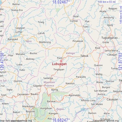
Lubuagan GPS coordinates[2]
17° 21' 17.28" North, 121° 10' 28.92" East
| Map corner | latitude | longitude |
|---|---|---|
| Upper-left | 18.02467°, | 120.47158° |
| Center: | 17.3548°, | 121.1747° |
| Lower-right: | 16.68247°, | 121.87783° |
| Map W x H: | 149.2×149.2 km | = 92.7×92.7mi |
| max Lat: | 20.78733° ⇑4.6% North |
| Lubuagan: | 17.3548° |
| min Lat: | ⇓95.4% South 4.65442° |
| min Long | Lubuagan | max Long |
| 117.04868° | 121.1747° | 126.58417° |
| W 27.9%⇐ | ⇒72.1% E |
Elevation
Elevation of Lubuagan is 816 m = 2677 ft, and this is 728.1 m = 2389 ft above average elevation for this country.
| Max E: |
2262 m = 7421 ft | 1.6% |
| Lubuagan | 816 m 2677 ft | |
| Avg. | 87.9 m = 288 ft | |
Min E: |
-2 m = -7 ft | 98.4% |
See also: Philippines elevation on elevation.city.
Geographical zone
Lubuagan is located in North Torrid zone (between Equator and Tropic of Cancer). Distance of this Northern Tropic circle is 676.2 km =420.2 mi to North.| Distance of | km | miles | from Lubuagan |
|---|---|---|---|
| North Pole | 8077.4 | 5019.1 | to North |
| Arctic Circle | 5471.5 | 3399.8 | to North |
| Tropic Cancer | 676.2 | 420.2 | to North |
| Equator | 1929.7 | 1199.1 | to South |


Nearby cities:
15 places around Lubuagan: (largest is in red/bold)
• Balbalan
10.1 km =6.3 mi,  16°
16°
• Barlig
36.1 km =22.4 mi,  192°
192°
• Betwagan
37.4 km =23.2 mi,  216°
216°
• Bontoc
36.4 km =22.6 mi, 215°
• Bucloc
34.9 km =21.7 mi,  285°
285°
• Daguioman
29.5 km =18.3 mi, 291°
• Laya
33.7 km =20.9 mi,  67°
67°
• Natonin
29.4 km =18.3 mi,  158°
158°
• Paracelis
32.5 km =20.2 mi,  107°
107°
• Pasil
5.4 km =3.4 mi,  305°
305°
• Sadanga
26.9 km =16.7 mi, 218°
• Tabuk
12.5 km =7.8 mi,  61°
61°
• Tabuk
33.8 km =21 mi, 66°
• Tanudan
9.4 km =5.8 mi,  134°
134°
• Tinglayan
8.8 km =5.5 mi, 188°
Sources, notices
• [Note1] Compared only with cities in Philippines existing in our database
• [Src1] Map data: © OpenStreetMap contributors (CC-BY-SA)
• [Src2] Other city data from geonames.org with taken over terms of usage.
• [Src3] Geographical zone / Annual Mean Temperature by Robert A. Rohde @ Wikipedia
