Adilpur geodata
Adilpur (Sindh) is a populated place; located in Pakistan in Asia/Karachi (GMT+5) time zone. With population of 8,247 people, there are 369 cities with bigger population in this country. Compared to other cities in Pakistan, 73.6% of cities are located further ↑North; 67.3% of cities are located further →East and 70.9% of cities have higher elevation than Adilpur. Note1


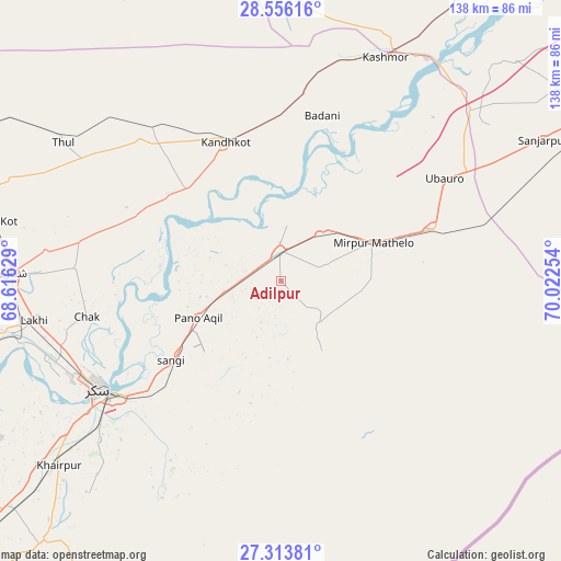
Adilpur GPS coordinates[2]
27° 56' 12.372" North, 69° 19' 9.876" East
| Map corner | latitude | longitude |
|---|---|---|
| Upper-left | 28.55616°, | 68.61629° |
| Center: | 27.93677°, | 69.31941° |
| Lower-right: | 27.31381°, | 70.02254° |
| Map W x H: | 138.1×138.1 km | = 85.8×85.8mi |
| max Lat: | 36.32162° ⇑73.6% North |
| Adilpur: | 27.93677° |
| min Lat: | ⇓26.4% South 24.14422° |
| min Long | Adilpur | max Long |
| 61.74573° | 69.31941° | 75.63372° |
| W 32.7%⇐ | ⇒67.3% E |
Elevation
Elevation of Adilpur is 77 m = 253 ft, and this is 268 m = 879 ft below average elevation for this country.
| Max E: |
2732 m = 8963 ft | 70.9% |
| Avg. | 345 m = 1132 ft | |
| Adilpur | 77 m = 253 ft | |
Min E: |
3 m = 10 ft | 29.1% |
See also: Pakistan elevation on elevation.city.
Geographical zone
Adilpur is located in North temperate zone (between Tropic of Cancer and the Arctic Circle). Distance of this Northern Tropic circle is 500.4 km =310.9 mi to South.| Distance of | km | miles | from Adilpur |
|---|---|---|---|
| North Pole | 6900.8 | 4288 | to North |
| Arctic Circle | 4294.9 | 2668.7 | to North |
| Tropic Cancer | 500.4 | 310.9 | to South |
| Equator | 3106.3 | 1930.2 | to South |


Nearby cities:
15 places around Adilpur: (largest is in red/bold)
• Bagarji
58.7 km =36.5 mi,  249°
249°
• Chak
48.5 km =30.1 mi,  259°
259°
• Ghauspur
32.3 km =20.1 mi,  314°
314°
• Ghotki
7.5 km =4.7 mi,  357°
357°
• Kandhkot
37 km =23 mi,  338°
338°
• Kashmor
60.9 km =37.8 mi,  25°
25°
• Khairpur
40.3 km =25 mi,  69°
69°
• Khanpur Mahar
14.1 km =8.8 mi,  139°
139°
• Mirpur Mathelo
24.4 km =15.2 mi, 67°
• Pano Aqil
22.3 km =13.9 mi, 246°
• Rohri
49.8 km =30.9 mi,  236°
236°
• Rustam
50.7 km =31.5 mi,  273°
273°
• Sukkur
52.2 km =32.4 mi, 240°
• Tangwani
49.4 km =30.7 mi,  320°
320°
• Ubauro
47.7 km =29.6 mi,  57°
57°
Sources, notices
• [Note1] Compared only with cities in Pakistan existing in our database
• [Src1] Map data: © OpenStreetMap contributors (CC-BY-SA)
• [Src2] Other city data from geonames.org with taken over terms of usage.
• [Src3] Geographical zone / Annual Mean Temperature by Robert A. Rohde @ Wikipedia
