Mirpur Mathelo geodata
Mirpur Mathelo (Sindh) is a populated place; located in Pakistan in Asia/Karachi (GMT+5) time zone. With population of 49,311 people, there are 131 cities with bigger population in this country. Compared to other cities in Pakistan, 72.5% of cities are located further ↑North; 65.7% of cities are located further →East and 71.1% of cities have higher elevation than Mirpur Mathelo. Note1


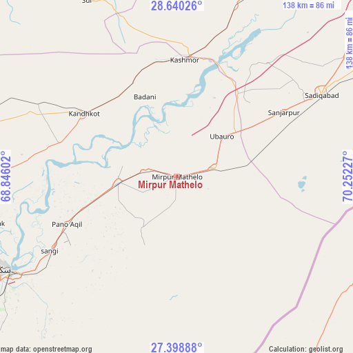
Mirpur Mathelo GPS coordinates[2]
28° 1' 16.896" North, 69° 32' 56.904" East
| Map corner | latitude | longitude |
|---|---|---|
| Upper-left | 28.64026°, | 68.84602° |
| Center: | 28.02136°, | 69.54914° |
| Lower-right: | 27.39888°, | 70.25227° |
| Map W x H: | 138×138 km | = 85.7×85.7mi |
| max Lat: | 36.32162° ⇑72.5% North |
| Mirpur Mathelo: | 28.02136° |
| min Lat: | ⇓27.5% South 24.14422° |
| min Long | Mirpur Mathelo | max Long |
| 61.74573° | 69.54914° | 75.63372° |
| W 34.3%⇐ | ⇒65.7% E |
Elevation
Elevation of Mirpur Mathelo is 76 m = 249 ft, and this is 269 m = 883 ft below average elevation for this country.
| Max E: |
2732 m = 8963 ft | 71.1% |
| Avg. | 345 m = 1132 ft | |
| Mirpur Mathelo | 76 m = 249 ft | |
Min E: |
3 m = 10 ft | 28.9% |
See also: Mirpur Mathelo elevation on elevation.city.
Geographical zone
Mirpur Mathelo is located in North temperate zone (between Tropic of Cancer and the Arctic Circle). Distance of this Northern Tropic circle is 509.8 km =316.8 mi to South.| Distance of | km | miles | from Mirpur Mathelo |
|---|---|---|---|
| North Pole | 6891.4 | 4282.1 | to North |
| Arctic Circle | 4285.5 | 2662.9 | to North |
| Tropic Cancer | 509.8 | 316.8 | to South |
| Equator | 3115.7 | 1936 | to South |


Nearby cities:
15 places around Mirpur Mathelo: (largest is in red/bold)
• Adilpur
24.4 km =15.2 mi,  247°
247°
• Chak
72.6 km =45.1 mi,  255°
255°
• Ghauspur
47.6 km =29.6 mi,  285°
285°
• Ghotki
23 km =14.3 mi,  265°
265°
• Kandhkot
44 km =27.3 mi,  304°
304°
• Kashmor
45.9 km =28.5 mi,  4°
4°
• Khairpur
15.9 km =9.9 mi,  72°
72°
• Khanpur Mahar
24.1 km =15 mi,  213°
213°
• Pano Aqil
46.8 km =29.1 mi, 246°
• Rohri
74 km =46 mi,  240°
240°
• Rustam
73.4 km =45.6 mi, 265°
• Saddiqabad
65 km =40.4 mi,  60°
60°
• Sukkur
76.5 km =47.5 mi, 242°
• Tangwani
61.2 km =38 mi, 297°
• Ubauro
23.9 km =14.9 mi,  48°
48°
Sources, notices
• [Note1] Compared only with cities in Pakistan existing in our database
• [Src1] Map data: © OpenStreetMap contributors (CC-BY-SA)
• [Src2] Other city data from geonames.org with taken over terms of usage.
• [Src3] Geographical zone / Annual Mean Temperature by Robert A. Rohde @ Wikipedia
