Rustam geodata
Rustam (Sindh) is a populated place; located in Pakistan in Asia/Karachi (GMT+5) time zone. With population of 9,048 people, there are 358 cities with bigger population in this country. Compared to other cities in Pakistan, 73.1% of cities are located further ↑North; 72.9% of cities are located further →East and 73.6% of cities have higher elevation than Rustam. Note1


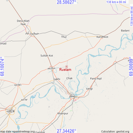
Rustam GPS coordinates[2]
27° 58' 1.38" North, 68° 48' 13.896" East
| Map corner | latitude | longitude |
|---|---|---|
| Upper-left | 28.58627°, | 68.10074° |
| Center: | 27.96705°, | 68.80386° |
| Lower-right: | 27.34426°, | 69.50699° |
| Map W x H: | 138.1×138.1 km | = 85.8×85.8mi |
| max Lat: | 36.32162° ⇑73.1% North |
| Rustam: | 27.96705° |
| min Lat: | ⇓26.9% South 24.14422° |
| min Long | Rustam | max Long |
| 61.74573° | 68.80386° | 75.63372° |
| W 27.1%⇐ | ⇒72.9% E |
Elevation
Elevation of Rustam is 70 m = 230 ft, and this is 275 m = 902 ft below average elevation for this country.
| Max E: |
2732 m = 8963 ft | 73.6% |
| Avg. | 345 m = 1132 ft | |
| Rustam | 70 m = 230 ft | |
Min E: |
3 m = 10 ft | 26.4% |
See also: Pakistan elevation on elevation.city.
Geographical zone
Rustam is located in North temperate zone (between Tropic of Cancer and the Arctic Circle). Distance of this Northern Tropic circle is 503.7 km =313 mi to South.| Distance of | km | miles | from Rustam |
|---|---|---|---|
| North Pole | 6897.4 | 4285.8 | to North |
| Arctic Circle | 4291.5 | 2666.6 | to North |
| Tropic Cancer | 503.7 | 313 | to South |
| Equator | 3109.6 | 1932.2 | to South |


Nearby cities:
15 places around Rustam: (largest is in red/bold)
• Bagarji
24.1 km =15 mi,  190°
190°
• Chak
12.4 km =7.7 mi,  166°
166°
• Garhiyasin
29.4 km =18.3 mi,  256°
256°
• Ghauspur
33.3 km =20.7 mi,  55°
55°
• Kandhkot
48.2 km =30 mi,  49°
49°
• Khairpur Mir’s
48.9 km =30.4 mi, 185°
• Lakhi
16.7 km =10.4 mi,  217°
217°
• Madeji
42 km =26.1 mi,  235°
235°
• Pano Aqil
32.6 km =20.3 mi,  112°
112°
• Pir Jo Goth
45.5 km =28.3 mi,  203°
203°
• Rohri
31.9 km =19.8 mi,  163°
163°
• Shikarpur
16.3 km =10.1 mi,  265°
265°
• Sukkur
29.8 km =18.5 mi, 169°
• Tangwani
39.5 km =24.5 mi,  28°
28°
• Thul
30.5 km =19 mi,  354°
354°
Sources, notices
• [Note1] Compared only with cities in Pakistan existing in our database
• [Src1] Map data: © OpenStreetMap contributors (CC-BY-SA)
• [Src2] Other city data from geonames.org with taken over terms of usage.
• [Src3] Geographical zone / Annual Mean Temperature by Robert A. Rohde @ Wikipedia
