Ghauspur geodata
Ghauspur (Sindh) is a populated place; located in Pakistan in Asia/Karachi (GMT+5) time zone. With population of 29,767 people, there are 209 cities with bigger population in this country. Compared to other cities in Pakistan, 71.6% of cities are located further ↑North; 69.1% of cities are located further →East and 71.6% of cities have higher elevation than Ghauspur. Note1


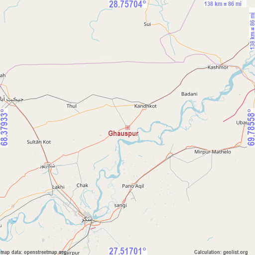
Ghauspur GPS coordinates[2]
28° 8' 19.752" North, 69° 4' 56.82" East
| Map corner | latitude | longitude |
|---|---|---|
| Upper-left | 28.75704°, | 68.37933° |
| Center: | 28.13882°, | 69.08245° |
| Lower-right: | 27.51701°, | 69.78558° |
| Map W x H: | 137.9×137.9 km | = 85.7×85.7mi |
| max Lat: | 36.32162° ⇑71.6% North |
| Ghauspur: | 28.13882° |
| min Lat: | ⇓28.4% South 24.14422° |
| min Long | Ghauspur | max Long |
| 61.74573° | 69.08245° | 75.63372° |
| W 30.9%⇐ | ⇒69.1% E |
Elevation
Elevation of Ghauspur is 73 m = 240 ft, and this is 272 m = 892 ft below average elevation for this country.
| Max E: |
2732 m = 8963 ft | 71.6% |
| Avg. | 345 m = 1132 ft | |
| Ghauspur | 73 m = 240 ft | |
Min E: |
3 m = 10 ft | 28.4% |
See also: Pakistan elevation on elevation.city.
Geographical zone
Ghauspur is located in North temperate zone (between Tropic of Cancer and the Arctic Circle). Distance of this Northern Tropic circle is 522.8 km =324.9 mi to South.| Distance of | km | miles | from Ghauspur |
|---|---|---|---|
| North Pole | 6878.3 | 4274 | to North |
| Arctic Circle | 4272.4 | 2654.7 | to North |
| Tropic Cancer | 522.8 | 324.9 | to South |
| Equator | 3128.7 | 1944.1 | to South |


Nearby cities:
15 places around Ghauspur: (largest is in red/bold)
• Adilpur
32.3 km =20.1 mi,  134°
134°
• Bagarji
53.3 km =33.1 mi,  216°
216°
• Chak
39.6 km =24.6 mi, 218°
• Ghotki
27.3 km =17 mi,  123°
123°
• Kandhkot
15.2 km =9.4 mi,  38°
38°
• Khanpur Mahar
46.4 km =28.8 mi,  135°
135°
• Lakhi
49.5 km =30.8 mi,  229°
229°
• Mirpur Mathelo
47.6 km =29.6 mi,  105°
105°
• Pano Aqil
31.6 km =19.6 mi,  174°
174°
• Rohri
53 km =32.9 mi,  200°
200°
• Rustam
33.3 km =20.7 mi,  235°
235°
• Shikarpur
48.1 km =29.9 mi, 244°
• Sukkur
53.2 km =33.1 mi, 204°
• Tangwani
17.7 km =11 mi,  331°
331°
• Thul
32.1 km =19.9 mi,  290°
290°
Sources, notices
• [Note1] Compared only with cities in Pakistan existing in our database
• [Src1] Map data: © OpenStreetMap contributors (CC-BY-SA)
• [Src2] Other city data from geonames.org with taken over terms of usage.
• [Src3] Geographical zone / Annual Mean Temperature by Robert A. Rohde @ Wikipedia
