Ubauro geodata
Ubauro (Sindh) is a populated place; located in Pakistan in Asia/Karachi (GMT+5) time zone. With population of 23,462 people, there are 249 cities with bigger population in this country. Compared to other cities in Pakistan, 71.3% of cities are located further ↑North; 63.9% of cities are located further →East and 71.3% of cities have higher elevation than Ubauro. Note1


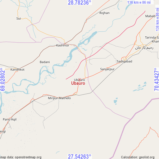
Ubauro GPS coordinates[2]
28° 9' 51.444" North, 69° 43' 52.104" East
| Map corner | latitude | longitude |
|---|---|---|
| Upper-left | 28.78236°, | 69.02802° |
| Center: | 28.16429°, | 69.73114° |
| Lower-right: | 27.54263°, | 70.43427° |
| Map W x H: | 137.8×137.8 km | = 85.6×85.6mi |
| max Lat: | 36.32162° ⇑71.3% North |
| Ubauro: | 28.16429° |
| min Lat: | ⇓28.7% South 24.14422° |
| min Long | Ubauro | max Long |
| 61.74573° | 69.73114° | 75.63372° |
| W 36.1%⇐ | ⇒63.9% E |
Elevation
Elevation of Ubauro is 74 m = 243 ft, and this is 271 m = 889 ft below average elevation for this country.
| Max E: |
2732 m = 8963 ft | 71.3% |
| Avg. | 345 m = 1132 ft | |
| Ubauro | 74 m = 243 ft | |
Min E: |
3 m = 10 ft | 28.7% |
See also: Pakistan elevation on elevation.city.
Geographical zone
Ubauro is located in North temperate zone (between Tropic of Cancer and the Arctic Circle). Distance of this Northern Tropic circle is 525.7 km =326.7 mi to South.| Distance of | km | miles | from Ubauro |
|---|---|---|---|
| North Pole | 6875.5 | 4272.2 | to North |
| Arctic Circle | 4269.6 | 2653 | to North |
| Tropic Cancer | 525.7 | 326.7 | to South |
| Equator | 3131.6 | 1945.9 | to South |


Nearby cities:
15 places around Ubauro: (largest is in red/bold)
• Adilpur
47.7 km =29.6 mi,  237°
237°
• Ghauspur
63.7 km =39.6 mi,  267°
267°
• Ghotki
44.5 km =27.7 mi,  246°
246°
• Kandhkot
54.8 km =34.1 mi,  279°
279°
• Kashmor
33.1 km =20.6 mi,  334°
334°
• Khairpur
11.4 km =7.1 mi,  193°
193°
• Khanpur Mahar
47.6 km =29.6 mi,  220°
220°
• Kot Samaba
84 km =52.2 mi,  59°
59°
• Mirpur Mathelo
23.9 km =14.9 mi,  228°
228°
• Pano Aqil
69.8 km =43.4 mi, 240°
• Rahim Yar Khan
62.8 km =39 mi, 63°
• Rojhan
62.1 km =38.6 mi,  20°
20°
• Rustam
93.6 km =58.2 mi,  256°
256°
• Saddiqabad
41.9 km =26 mi,  67°
67°
• Tangwani
73 km =45.4 mi, 280°
Sources, notices
• [Note1] Compared only with cities in Pakistan existing in our database
• [Src1] Map data: © OpenStreetMap contributors (CC-BY-SA)
• [Src2] Other city data from geonames.org with taken over terms of usage.
• [Src3] Geographical zone / Annual Mean Temperature by Robert A. Rohde @ Wikipedia
