Pano Aqil geodata
Pano Aqil (Sindh) is a populated place; located in Pakistan in Asia/Karachi (GMT+5) time zone. With population of 72,881 people, there are 91 cities with bigger population in this country. Compared to other cities in Pakistan, 74.3% of cities are located further ↑North; 68.6% of cities are located further →East and 73.8% of cities have higher elevation than Pano Aqil. Note1


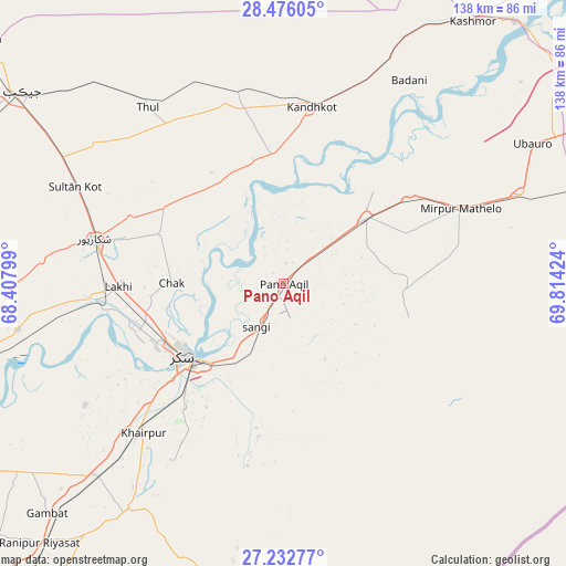
Pano Aqil GPS coordinates[2]
27° 51' 22.284" North, 69° 6' 39.996" East
| Map corner | latitude | longitude |
|---|---|---|
| Upper-left | 28.47605°, | 68.40799° |
| Center: | 27.85619°, | 69.11111° |
| Lower-right: | 27.23277°, | 69.81424° |
| Map W x H: | 138.2×138.2 km | = 85.9×85.9mi |
| max Lat: | 36.32162° ⇑74.3% North |
| Pano Aqil: | 27.85619° |
| min Lat: | ⇓25.7% South 24.14422° |
| min Long | Pano Aqil | max Long |
| 61.74573° | 69.11111° | 75.63372° |
| W 31.4%⇐ | ⇒68.6% E |
Elevation
Elevation of Pano Aqil is 69 m = 226 ft, and this is 276 m = 906 ft below average elevation for this country.
| Max E: |
2732 m = 8963 ft | 73.8% |
| Avg. | 345 m = 1132 ft | |
| Pano Aqil | 69 m = 226 ft | |
Min E: |
3 m = 10 ft | 26.2% |
See also: Pano Aqil elevation on elevation.city.
Geographical zone
Pano Aqil is located in North temperate zone (between Tropic of Cancer and the Arctic Circle). Distance of this Northern Tropic circle is 491.4 km =305.3 mi to South.| Distance of | km | miles | from Pano Aqil |
|---|---|---|---|
| North Pole | 6909.7 | 4293.5 | to North |
| Arctic Circle | 4303.9 | 2674.3 | to North |
| Tropic Cancer | 491.4 | 305.3 | to South |
| Equator | 3097.3 | 1924.6 | to South |


Nearby cities:
15 places around Pano Aqil: (largest is in red/bold)
• Adilpur
22.3 km =13.9 mi,  66°
66°
• Bagarji
36.5 km =22.7 mi,  251°
251°
• Chak
27.3 km =17 mi,  270°
270°
• Ghauspur
31.6 km =19.6 mi,  354°
354°
• Ghotki
26 km =16.2 mi,  50°
50°
• Kandhkot
43.8 km =27.2 mi,  8°
8°
• Khairpur Mir’s
50.2 km =31.2 mi,  223°
223°
• Khanpur Mahar
29.7 km =18.5 mi,  93°
93°
• Lakhi
40.5 km =25.2 mi, 268°
• Mirpur Mathelo
46.8 km =29.1 mi, 66°
• Rohri
28 km =17.4 mi,  229°
229°
• Rustam
32.6 km =20.3 mi,  292°
292°
• Shikarpur
47.8 km =29.7 mi,  283°
283°
• Sukkur
30.1 km =18.7 mi,  235°
235°
• Tangwani
48.3 km =30 mi, 346°
Sources, notices
• [Note1] Compared only with cities in Pakistan existing in our database
• [Src1] Map data: © OpenStreetMap contributors (CC-BY-SA)
• [Src2] Other city data from geonames.org with taken over terms of usage.
• [Src3] Geographical zone / Annual Mean Temperature by Robert A. Rohde @ Wikipedia
