Ghotki geodata
Ghotki (Sindh) is a seat of a second-order administrative division; located in Pakistan in Asia/Karachi (GMT+5) time zone. With population of 64,295 people, there are 112 cities with bigger population in this country. Compared to other cities in Pakistan, 72.9% of cities are located further ↑North; 67.5% of cities are located further →East and 73.1% of cities have higher elevation than Ghotki. Note1


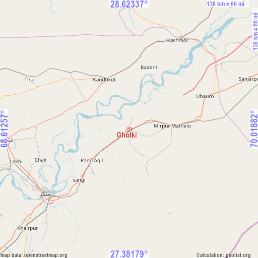
Ghotki GPS coordinates[2]
28° 0' 15.732" North, 69° 18' 56.484" East
| Map corner | latitude | longitude |
|---|---|---|
| Upper-left | 28.62337°, | 68.61257° |
| Center: | 28.00437°, | 69.31569° |
| Lower-right: | 27.38179°, | 70.01882° |
| Map W x H: | 138.1×138.1 km | = 85.8×85.8mi |
| max Lat: | 36.32162° ⇑72.9% North |
| Ghotki: | 28.00437° |
| min Lat: | ⇓27.1% South 24.14422° |
| min Long | Ghotki | max Long |
| 61.74573° | 69.31569° | 75.63372° |
| W 32.5%⇐ | ⇒67.5% E |
Elevation
Elevation of Ghotki is 71 m = 233 ft, and this is 274 m = 899 ft below average elevation for this country.
| Max E: |
2732 m = 8963 ft | 73.1% |
| Avg. | 345 m = 1132 ft | |
| Ghotki | 71 m = 233 ft | |
Min E: |
3 m = 10 ft | 26.9% |
See also: Ghotki elevation on elevation.city.
Geographical zone
Ghotki is located in North temperate zone (between Tropic of Cancer and the Arctic Circle). Distance of this Northern Tropic circle is 507.9 km =315.6 mi to South.| Distance of | km | miles | from Ghotki |
|---|---|---|---|
| North Pole | 6893.3 | 4283.3 | to North |
| Arctic Circle | 4287.4 | 2664.1 | to North |
| Tropic Cancer | 507.9 | 315.6 | to South |
| Equator | 3113.8 | 1934.8 | to South |


Nearby cities:
15 places around Ghotki: (largest is in red/bold)
• Adilpur
7.5 km =4.7 mi,  177°
177°
• Chak
50 km =31.1 mi,  251°
251°
• Ghauspur
27.3 km =17 mi,  303°
303°
• Kandhkot
30 km =18.6 mi,  333°
333°
• Kashmor
54.4 km =33.8 mi,  28°
28°
• Khairpur
38.7 km =24 mi,  80°
80°
• Khanpur Mahar
20.5 km =12.7 mi,  152°
152°
• Mirpur Mathelo
23 km =14.3 mi,  85°
85°
• Pano Aqil
26 km =16.2 mi,  230°
230°
• Rohri
54 km =33.6 mi, 229°
• Rustam
50.4 km =31.3 mi,  265°
265°
• Sukkur
56 km =34.8 mi, 233°
• Tangwani
43.6 km =27.1 mi,  314°
314°
• Thul
59.1 km =36.7 mi, 296°
• Ubauro
44.5 km =27.7 mi,  66°
66°
Sources, notices
• [Note1] Compared only with cities in Pakistan existing in our database
• [Src1] Map data: © OpenStreetMap contributors (CC-BY-SA)
• [Src2] Other city data from geonames.org with taken over terms of usage.
• [Src3] Geographical zone / Annual Mean Temperature by Robert A. Rohde @ Wikipedia
