Taunsa geodata
Taunsa (Punjab) is a populated place; located in Pakistan in Asia/Karachi (GMT+5) time zone. With population of 44,869 people, there are 144 cities with bigger population in this country. Compared to other cities in Pakistan, 51% of cities are located further ↑North; 58.9% of cities are located further →East and 51.5% of cities have higher elevation than Taunsa. Note1


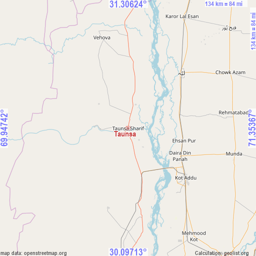
Taunsa GPS coordinates[2]
30° 42' 12.888" North, 70° 39' 1.944" East
| Map corner | latitude | longitude |
|---|---|---|
| Upper-left | 31.30624°, | 69.94742° |
| Center: | 30.70358°, | 70.65054° |
| Lower-right: | 30.09713°, | 71.35367° |
| Map W x H: | 134.4×134.4 km | = 83.5×83.5mi |
| max Lat: | 36.32162° ⇑51% North |
| Taunsa: | 30.70358° |
| min Lat: | ⇓49% South 24.14422° |
| min Long | Taunsa | max Long |
| 61.74573° | 70.65054° | 75.63372° |
| W 41.1%⇐ | ⇒58.9% E |
Elevation
Elevation of Taunsa is 175 m = 574 ft, and this is 170 m = 558 ft below average elevation for this country.
| Max E: |
2732 m = 8963 ft | 51.5% |
| Avg. | 345 m = 1132 ft | |
| Taunsa | 175 m = 574 ft | |
Min E: |
3 m = 10 ft | 48.5% |
See also: Taunsa elevation on elevation.city.
Geographical zone
Taunsa is located in North temperate zone (between Tropic of Cancer and the Arctic Circle). Distance of this Northern Tropic circle is 808 km =502.1 mi to South.| Distance of | km | miles | from Taunsa |
|---|---|---|---|
| North Pole | 6593.1 | 4096.8 | to North |
| Arctic Circle | 3987.3 | 2477.6 | to North |
| Tropic Cancer | 808 | 502.1 | to South |
| Equator | 3413.9 | 2121.3 | to South |


Nearby cities:
15 places around Taunsa: (largest is in red/bold)
• Bakhri Ahmad Khan
18.3 km =11.4 mi,  78°
78°
• Basti Aukharvand
21.3 km =13.2 mi,  68°
68°
• Basti Dosa
22.8 km =14.2 mi, 65°
• Chak Two Hundred Forty-nine Thal Development Authority
74.7 km =46.4 mi,  45°
45°
• Daira Din Panah
31.2 km =19.4 mi,  118°
118°
• Dajjal wala
24 km =14.9 mi, 69°
• Dera Ghazi Khan
73.1 km =45.4 mi,  180°
180°
• Karor
64.7 km =40.2 mi,  26°
26°
• Kot Addu
40 km =24.9 mi,  130°
130°
• Kot Sultan
27.9 km =17.3 mi, 73°
• Layyah
39.7 km =24.7 mi,  43°
43°
• Moza Shahwala
22.1 km =13.7 mi,  59°
59°
• Multan
97.3 km =60.5 mi, 125°
• Musa Khel Bazar
81 km =50.3 mi,  282°
282°
• Muzaffargarh
87.4 km =54.3 mi,  143°
143°
Sources, notices
• [Note1] Compared only with cities in Pakistan existing in our database
• [Src1] Map data: © OpenStreetMap contributors (CC-BY-SA)
• [Src2] Other city data from geonames.org with taken over terms of usage.
• [Src3] Geographical zone / Annual Mean Temperature by Robert A. Rohde @ Wikipedia
