Daira Din Panah geodata
Daira Din Panah (Punjab) is a populated place; located in Pakistan in Asia/Karachi (GMT+5) time zone. With population of 14,878 people, there are 314 cities with bigger population in this country. Compared to other cities in Pakistan, 52.8% of cities are located further ↑North; 55.5% of cities are located further →East and 62.3% of cities have higher elevation than Daira Din Panah. Note1


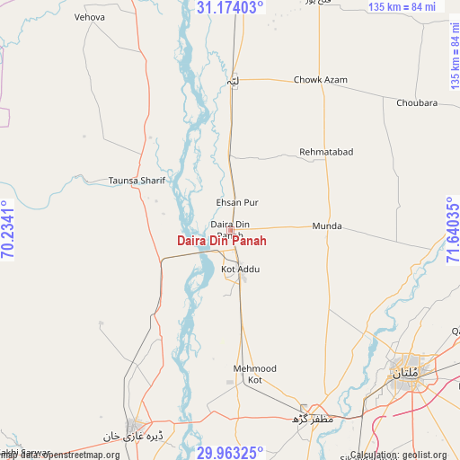
Daira Din Panah GPS coordinates[2]
30° 34' 13.908" North, 70° 56' 13.992" East
| Map corner | latitude | longitude |
|---|---|---|
| Upper-left | 31.17403°, | 70.2341° |
| Center: | 30.57053°, | 70.93722° |
| Lower-right: | 29.96325°, | 71.64035° |
| Map W x H: | 134.6×134.6 km | = 83.6×83.6mi |
| max Lat: | 36.32162° ⇑52.8% North |
| Daira Din Panah: | 30.57053° |
| min Lat: | ⇓47.2% South 24.14422° |
| min Long | Daira Din Panah | max Long |
| 61.74573° | 70.93722° | 75.63372° |
| W 44.5%⇐ | ⇒55.5% E |
Elevation
Elevation of Daira Din Panah is 139 m = 456 ft, and this is 206 m = 676 ft below average elevation for this country.
| Max E: |
2732 m = 8963 ft | 62.3% |
| Avg. | 345 m = 1132 ft | |
| Daira Din Panah | 139 m = 456 ft | |
Min E: |
3 m = 10 ft | 37.7% |
See also: Pakistan elevation on elevation.city.
Geographical zone
Daira Din Panah is located in North temperate zone (between Tropic of Cancer and the Arctic Circle). Distance of this Northern Tropic circle is 793.2 km =492.9 mi to South.| Distance of | km | miles | from Daira Din Panah |
|---|---|---|---|
| North Pole | 6607.9 | 4106 | to North |
| Arctic Circle | 4002 | 2486.7 | to North |
| Tropic Cancer | 793.2 | 492.9 | to South |
| Equator | 3399.1 | 2112.1 | to South |


Nearby cities:
15 places around Daira Din Panah: (largest is in red/bold)
• Bakhri Ahmad Khan
20.7 km =12.9 mi,  332°
332°
• Basti Aukharvand
23.8 km =14.8 mi,  341°
341°
• Basti Dosa
25 km =15.5 mi, 344°
• Chak Two Hundred Forty-nine Thal Development Authority
72.2 km =44.9 mi,  20°
20°
• Dajjal wala
23.7 km =14.7 mi,  347°
347°
• Dera Ghazi Khan
64.9 km =40.3 mi,  206°
206°
• Karor
72.7 km =45.2 mi,  1°
1°
• Khangarh
76 km =47.2 mi,  163°
163°
• Kot Addu
11.6 km =7.2 mi,  165°
165°
• Kot Sultan
22.6 km =14 mi,  358°
358°
• Layyah
43.4 km =27 mi, 0°
• Moza Shahwala
27.5 km =17.1 mi, 342°
• Multan
66.5 km =41.3 mi,  128°
128°
• Muzaffargarh
60.6 km =37.7 mi, 156°
• Taunsa
31.2 km =19.4 mi,  298°
298°
Sources, notices
• [Note1] Compared only with cities in Pakistan existing in our database
• [Src1] Map data: © OpenStreetMap contributors (CC-BY-SA)
• [Src2] Other city data from geonames.org with taken over terms of usage.
• [Src3] Geographical zone / Annual Mean Temperature by Robert A. Rohde @ Wikipedia
