Layyah geodata
Layyah (Punjab) is a seat of a second-order administrative division; located in Pakistan in Asia/Karachi (GMT+5) time zone. With population of 78,954 people, there are 82 cities with bigger population in this country. Compared to other cities in Pakistan, 53.7% of cities are located further ↓South; 55.3% of cities are located further →East and 58.7% of cities have higher elevation than Layyah. Note1


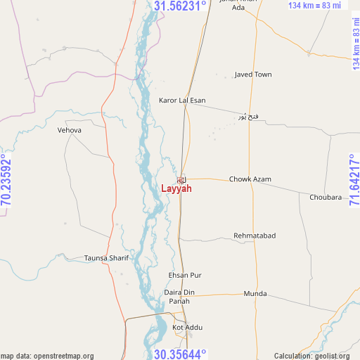
Layyah GPS coordinates[2]
30° 57' 40.608" North, 70° 56' 20.544" East
| Map corner | latitude | longitude |
|---|---|---|
| Upper-left | 31.56231°, | 70.23592° |
| Center: | 30.96128°, | 70.93904° |
| Lower-right: | 30.35644°, | 71.64217° |
| Map W x H: | 134.1×134.1 km | = 83.3×83.3mi |
| max Lat: | 36.32162° ⇑46.3% North |
| Layyah: | 30.96128° |
| min Lat: | ⇓53.7% South 24.14422° |
| min Long | Layyah | max Long |
| 61.74573° | 70.93904° | 75.63372° |
| W 44.7%⇐ | ⇒55.3% E |
Elevation
Elevation of Layyah is 151 m = 495 ft, and this is 194 m = 636 ft below average elevation for this country.
| Max E: |
2732 m = 8963 ft | 58.7% |
| Avg. | 345 m = 1132 ft | |
| Layyah | 151 m = 495 ft | |
Min E: |
3 m = 10 ft | 41.3% |
See also: Layyah elevation on elevation.city.
Geographical zone
Layyah is located in North temperate zone (between Tropic of Cancer and the Arctic Circle). Distance of this Northern Tropic circle is 836.7 km =519.9 mi to South.| Distance of | km | miles | from Layyah |
|---|---|---|---|
| North Pole | 6564.5 | 4079 | to North |
| Arctic Circle | 3958.6 | 2459.8 | to North |
| Tropic Cancer | 836.7 | 519.9 | to South |
| Equator | 3442.6 | 2139.1 | to South |


Nearby cities:
15 places around Layyah: (largest is in red/bold)
• Ahmadpur Sial
83 km =51.6 mi,  112°
112°
• Bakhri Ahmad Khan
26.9 km =16.7 mi,  201°
201°
• Basti Aukharvand
22.3 km =13.9 mi, 200°
• Basti Dosa
20.4 km =12.7 mi, 199°
• Bhakkar
75 km =46.6 mi,  9°
9°
• Chak Two Hundred Forty-nine Thal Development Authority
34.9 km =21.7 mi,  46°
46°
• Daira Din Panah
43.4 km =27 mi,  180°
180°
• Dajjal wala
20.9 km =13 mi,  194°
194°
• Darya Khan
92.8 km =57.7 mi, 9°
• Karor
29.3 km =18.2 mi,  2°
2°
• Kot Addu
54.8 km =34.1 mi, 177°
• Kot Sultan
20.9 km =13 mi, 182°
• Mankera
67.3 km =41.8 mi, 45°
• Moza Shahwala
19.3 km =12 mi,  206°
206°
• Taunsa
39.7 km =24.7 mi,  223°
223°
Sources, notices
• [Note1] Compared only with cities in Pakistan existing in our database
• [Src1] Map data: © OpenStreetMap contributors (CC-BY-SA)
• [Src2] Other city data from geonames.org with taken over terms of usage.
• [Src3] Geographical zone / Annual Mean Temperature by Robert A. Rohde @ Wikipedia
