Karor geodata
Karor (Punjab) is a populated place; located in Pakistan in Asia/Karachi (GMT+5) time zone. With population of 25,634 people, there are 236 cities with bigger population in this country. Compared to other cities in Pakistan, 56.4% of cities are located further ↓South; 55.1% of cities are located further →East and 57.6% of cities have higher elevation than Karor. Note1


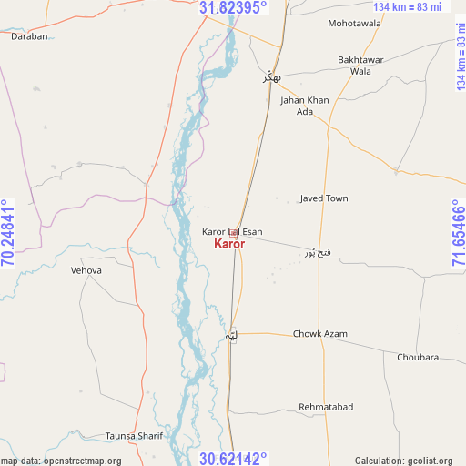
Karor GPS coordinates[2]
31° 13' 28.56" North, 70° 57' 5.508" East
| Map corner | latitude | longitude |
|---|---|---|
| Upper-left | 31.82395°, | 70.24841° |
| Center: | 31.2246°, | 70.95153° |
| Lower-right: | 30.62142°, | 71.65466° |
| Map W x H: | 133.7×133.7 km | = 83.1×83.1mi |
| max Lat: | 36.32162° ⇑43.6% North |
| Karor: | 31.2246° |
| min Lat: | ⇓56.4% South 24.14422° |
| min Long | Karor | max Long |
| 61.74573° | 70.95153° | 75.63372° |
| W 44.9%⇐ | ⇒55.1% E |
Elevation
Elevation of Karor is 157 m = 515 ft, and this is 188 m = 617 ft below average elevation for this country.
| Max E: |
2732 m = 8963 ft | 57.6% |
| Avg. | 345 m = 1132 ft | |
| Karor | 157 m = 515 ft | |
Min E: |
3 m = 10 ft | 42.4% |
See also: Pakistan elevation on elevation.city.
Geographical zone
Karor is located in North temperate zone (between Tropic of Cancer and the Arctic Circle). Distance of this Northern Tropic circle is 865.9 km =538 mi to South.| Distance of | km | miles | from Karor |
|---|---|---|---|
| North Pole | 6535.2 | 4060.8 | to North |
| Arctic Circle | 3929.3 | 2441.6 | to North |
| Tropic Cancer | 865.9 | 538 | to South |
| Equator | 3471.9 | 2157.3 | to South |


Nearby cities:
15 places around Karor: (largest is in red/bold)
• Bakhri Ahmad Khan
55.4 km =34.4 mi,  191°
191°
• Basti Aukharvand
50.9 km =31.6 mi, 190°
• Basti Dosa
49.2 km =30.6 mi, 189°
• Bhakkar
46 km =28.6 mi,  13°
13°
• Chak Two Hundred Forty-nine Thal Development Authority
24.6 km =15.3 mi,  102°
102°
• Daira Din Panah
72.7 km =45.2 mi,  181°
181°
• Dajjal wala
50 km =31.1 mi, 187°
• Darya Khan
63.9 km =39.7 mi, 12°
• Dera Ismail Khan
67.6 km =42 mi,  355°
355°
• Kot Sultan
50.2 km =31.2 mi, 182°
• Layyah
29.3 km =18.2 mi, 182°
• Mankera
49.9 km =31 mi,  68°
68°
• Moza Shahwala
47.6 km =29.6 mi, 191°
• Shorkot
76.6 km =47.6 mi,  354°
354°
• Taunsa
64.7 km =40.2 mi,  206°
206°
Sources, notices
• [Note1] Compared only with cities in Pakistan existing in our database
• [Src1] Map data: © OpenStreetMap contributors (CC-BY-SA)
• [Src2] Other city data from geonames.org with taken over terms of usage.
• [Src3] Geographical zone / Annual Mean Temperature by Robert A. Rohde @ Wikipedia
