Muzaffargarh geodata
Muzaffargarh (Punjab) is a seat of a second-order administrative division; located in Pakistan in Asia/Karachi (GMT+5) time zone. With population of 165,192 people, there are 38 cities with bigger population in this country. Compared to other cities in Pakistan, 58.2% of cities are located further ↑North; 52.6% of cities are located further →East and 66.6% of cities have higher elevation than Muzaffargarh. Note1


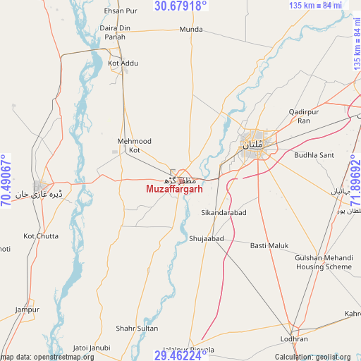
Muzaffargarh GPS coordinates[2]
30° 4' 21.288" North, 71° 11' 37.644" East
| Map corner | latitude | longitude |
|---|---|---|
| Upper-left | 30.67918°, | 70.49067° |
| Center: | 30.07258°, | 71.19379° |
| Lower-right: | 29.46224°, | 71.89692° |
| Map W x H: | 135.3×135.3 km | = 84.1×84.1mi |
| max Lat: | 36.32162° ⇑58.2% North |
| Muzaffargarh: | 30.07258° |
| min Lat: | ⇓41.8% South 24.14422° |
| min Long | Muzaffargarh | max Long |
| 61.74573° | 71.19379° | 75.63372° |
| W 47.4%⇐ | ⇒52.6% E |
Elevation
Elevation of Muzaffargarh is 120 m = 394 ft, and this is 225 m = 738 ft below average elevation for this country.
| Max E: |
2732 m = 8963 ft | 66.6% |
| Avg. | 345 m = 1132 ft | |
| Muzaffargarh | 120 m = 394 ft | |
Min E: |
3 m = 10 ft | 33.4% |
See also: Muzaffargarh elevation on elevation.city.
Geographical zone
Muzaffargarh is located in North temperate zone (between Tropic of Cancer and the Arctic Circle). Distance of this Northern Tropic circle is 737.8 km =458.4 mi to South.| Distance of | km | miles | from Muzaffargarh |
|---|---|---|---|
| North Pole | 6663.3 | 4140.4 | to North |
| Arctic Circle | 4057.4 | 2521.2 | to North |
| Tropic Cancer | 737.8 | 458.4 | to South |
| Equator | 3343.8 | 2077.7 | to South |


Nearby cities:
15 places around Muzaffargarh: (largest is in red/bold)
• Daira Din Panah
60.6 km =37.7 mi,  336°
336°
• Dera Ghazi Khan
53.3 km =33.1 mi,  266°
266°
• Dunyapur
60.9 km =37.8 mi,  119°
119°
• Jalalpur Pirwala
63.2 km =39.3 mi,  177°
177°
• Jampur
75 km =46.6 mi,  230°
230°
• Jatoi Shimali
70.2 km =43.6 mi,  208°
208°
• Kabirwala
74.1 km =46 mi,  60°
60°
• Khanewal
75.4 km =46.9 mi,  70°
70°
• Khangarh
17.9 km =11.1 mi,  190°
190°
• Kot Addu
49.2 km =30.6 mi,  333°
333°
• Lodhran
73.3 km =45.5 mi,  144°
144°
• Multan
30.6 km =19 mi, 63°
• Qadirpur Ran
52 km =32.3 mi, 62°
• Shahr Sultan
57.7 km =35.9 mi,  196°
196°
• Shujaabad
23.4 km =14.5 mi,  155°
155°
Sources, notices
• [Note1] Compared only with cities in Pakistan existing in our database
• [Src1] Map data: © OpenStreetMap contributors (CC-BY-SA)
• [Src2] Other city data from geonames.org with taken over terms of usage.
• [Src3] Geographical zone / Annual Mean Temperature by Robert A. Rohde @ Wikipedia
