Multan geodata
Multan (Punjab) is a seat of a second-order administrative division; located in Pakistan in Asia/Karachi (GMT+5) time zone. With population of 1,437,230 people, there are 4 cities with bigger population in this country. Compared to other cities in Pakistan, 56.9% of cities are located further ↑North; 50.1% of cities are located further →East and 64.6% of cities have higher elevation than Multan. Note1


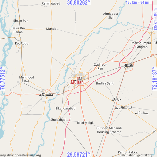
Multan GPS coordinates[2]
30° 11' 48.444" North, 71° 28' 41.664" East
| Map corner | latitude | longitude |
|---|---|---|
| Upper-left | 30.80262°, | 70.77512° |
| Center: | 30.19679°, | 71.47824° |
| Lower-right: | 29.58721°, | 72.18137° |
| Map W x H: | 135.1×135.1 km | = 83.9×83.9mi |
| max Lat: | 36.32162° ⇑56.9% North |
| Multan: | 30.19679° |
| min Lat: | ⇓43.1% South 24.14422° |
| min Long | Multan | max Long |
| 61.74573° | 71.47824° | 75.63372° |
| W 49.9%⇐ | ⇒50.1% E |
Elevation
Elevation of Multan is 126 m = 413 ft, and this is 219 m = 719 ft below average elevation for this country.
| Max E: |
2732 m = 8963 ft | 64.6% |
| Avg. | 345 m = 1132 ft | |
| Multan | 126 m = 413 ft | |
Min E: |
3 m = 10 ft | 35.4% |
See also: Multan elevation on elevation.city.
Geographical zone
Multan is located in North temperate zone (between Tropic of Cancer and the Arctic Circle). Distance of this Northern Tropic circle is 751.6 km =467 mi to South.| Distance of | km | miles | from Multan |
|---|---|---|---|
| North Pole | 6649.5 | 4131.8 | to North |
| Arctic Circle | 4043.6 | 2512.6 | to North |
| Tropic Cancer | 751.6 | 467 | to South |
| Equator | 3357.6 | 2086.3 | to South |


Nearby cities:
15 places around Multan: (largest is in red/bold)
• Ahmadpur Sial
59.2 km =36.8 mi,  25°
25°
• Daira Din Panah
66.5 km =41.3 mi,  308°
308°
• Dhanot
73.5 km =45.7 mi,  158°
158°
• Dunyapur
50.7 km =31.5 mi,  149°
149°
• Kabirwala
43.6 km =27.1 mi,  57°
57°
• Kahror Pakka
76.3 km =47.4 mi, 146°
• Khanewal
45.1 km =28 mi,  75°
75°
• Khangarh
43.8 km =27.2 mi,  224°
224°
• Kot Addu
57.7 km =35.9 mi,  301°
301°
• Lodhran
75.2 km =46.7 mi,  168°
168°
• Mailsi
80.1 km =49.8 mi,  123°
123°
• Muzaffargarh
30.6 km =19 mi,  243°
243°
• Qadirpur Ran
21.4 km =13.3 mi, 60°
• Sarai Sidhu
64.7 km =40.2 mi,  46°
46°
• Shujaabad
39.4 km =24.5 mi,  206°
206°
Sources, notices
• [Note1] Compared only with cities in Pakistan existing in our database
• [Src1] Map data: © OpenStreetMap contributors (CC-BY-SA)
• [Src2] Other city data from geonames.org with taken over terms of usage.
• [Src3] Geographical zone / Annual Mean Temperature by Robert A. Rohde @ Wikipedia
