Diplo geodata
Diplo (Sindh) is a populated place; located in Pakistan in Asia/Karachi (GMT+5) time zone. With population of 11,575 people, there are 342 cities with bigger population in this country. Compared to other cities in Pakistan, 99.3% of cities are located further ↑North; 64.8% of cities are located further →East and 96.6% of cities have higher elevation than Diplo. Note1


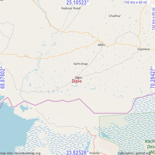
Diplo GPS coordinates[2]
24° 28' 0.768" North, 69° 34' 52.104" East
| Map corner | latitude | longitude |
|---|---|---|
| Upper-left | 25.10523°, | 68.87802° |
| Center: | 24.46688°, | 69.58114° |
| Lower-right: | 23.82528°, | 70.28427° |
| Map W x H: | 142.3×142.3 km | = 88.4×88.4mi |
| max Lat: | 36.32162° ⇑99.3% North |
| Diplo: | 24.46688° |
| min Lat: | ⇓0.7% South 24.14422° |
| min Long | Diplo | max Long |
| 61.74573° | 69.58114° | 75.63372° |
| W 35.2%⇐ | ⇒64.8% E |
Elevation
Elevation of Diplo is 12 m = 39 ft, and this is 333 m = 1093 ft below average elevation for this country.
| Max E: |
2732 m = 8963 ft | 96.6% |
| Avg. | 345 m = 1132 ft | |
| Diplo | 12 m = 39 ft | |
Min E: |
3 m = 10 ft | 3.4% |
See also: Pakistan elevation on elevation.city.
Geographical zone
Diplo is located in North temperate zone (between Tropic of Cancer and the Arctic Circle). Distance of this Northern Tropic circle is 114.5 km =71.1 mi to South.| Distance of | km | miles | from Diplo |
|---|---|---|---|
| North Pole | 7286.6 | 4527.7 | to North |
| Arctic Circle | 4680.7 | 2908.5 | to North |
| Tropic Cancer | 114.5 | 71.1 | to South |
| Equator | 2720.5 | 1690.4 | to South |


Nearby cities:
15 places around Diplo: (largest is in red/bold)
• Badin
78.1 km =48.5 mi,  285°
285°
• Digri
90.2 km =56 mi,  328°
328°
• Islamkot
65.8 km =40.9 mi,  66°
66°
• Kadhan
60.3 km =37.5 mi,  271°
271°
• Kario Ghanwar
105.7 km =65.7 mi, 291°
• Kunri
79.2 km =49.2 mi,  358°
358°
• Mirwah Gorchani
107.9 km =67 mi, 330°
• Mithi
37.1 km =23.1 mi,  36°
36°
• Nabisar
67 km =41.6 mi,  5°
5°
• Naukot
47.1 km =29.3 mi,  337°
337°
• Rajo Khanani
93.3 km =58 mi,  308°
308°
• Samaro
92.5 km =57.5 mi,  348°
348°
• Talhar
90.3 km =56.1 mi,  300°
300°
• Tando Bago
71.8 km =44.6 mi, 299°
• Umarkot
101 km =62.8 mi, 9°
Sources, notices
• [Note1] Compared only with cities in Pakistan existing in our database
• [Src1] Map data: © OpenStreetMap contributors (CC-BY-SA)
• [Src2] Other city data from geonames.org with taken over terms of usage.
• [Src3] Geographical zone / Annual Mean Temperature by Robert A. Rohde @ Wikipedia
