Naukot geodata
Naukot (Sindh) is a populated place; located in Pakistan in Asia/Karachi (GMT+5) time zone. With population of 22,081 people, there are 260 cities with bigger population in this country. Compared to other cities in Pakistan, 96.6% of cities are located further ↑North; 66.6% of cities are located further →East and 95.5% of cities have higher elevation than Naukot. Note1


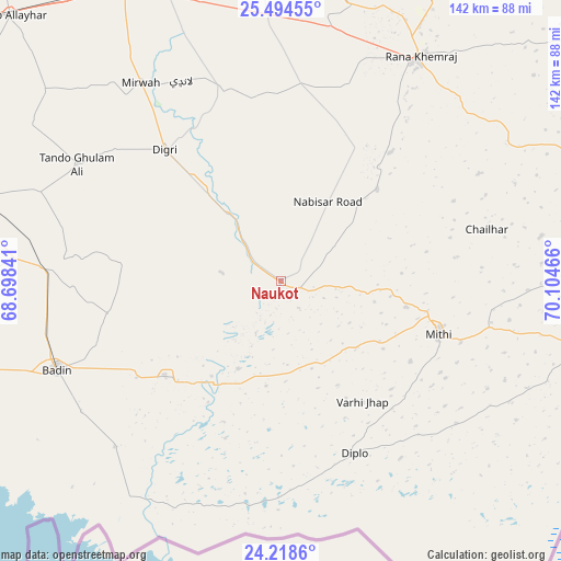
Naukot GPS coordinates[2]
24° 51' 29.592" North, 69° 24' 5.508" East
| Map corner | latitude | longitude |
|---|---|---|
| Upper-left | 25.49455°, | 68.69841° |
| Center: | 24.85822°, | 69.40153° |
| Lower-right: | 24.2186°, | 70.10466° |
| Map W x H: | 141.9×141.9 km | = 88.2×88.2mi |
| max Lat: | 36.32162° ⇑96.6% North |
| Naukot: | 24.85822° |
| min Lat: | ⇓3.4% South 24.14422° |
| min Long | Naukot | max Long |
| 61.74573° | 69.40153° | 75.63372° |
| W 33.4%⇐ | ⇒66.6% E |
Elevation
Elevation of Naukot is 14 m = 46 ft, and this is 331 m = 1086 ft below average elevation for this country.
| Max E: |
2732 m = 8963 ft | 95.5% |
| Avg. | 345 m = 1132 ft | |
| Naukot | 14 m = 46 ft | |
Min E: |
3 m = 10 ft | 4.5% |
See also: Pakistan elevation on elevation.city.
Geographical zone
Naukot is located in North temperate zone (between Tropic of Cancer and the Arctic Circle). Distance of this Northern Tropic circle is 158.1 km =98.2 mi to South.| Distance of | km | miles | from Naukot |
|---|---|---|---|
| North Pole | 7243.1 | 4500.7 | to North |
| Arctic Circle | 4637.2 | 2881.4 | to North |
| Tropic Cancer | 158.1 | 98.2 | to South |
| Equator | 2764 | 1717.5 | to South |


Nearby cities:
15 places around Naukot: (largest is in red/bold)
• Badin
61.3 km =38.1 mi,  248°
248°
• Dhoro Naro
73.9 km =45.9 mi,  13°
13°
• Digri
44.2 km =27.5 mi,  318°
318°
• Diplo
47.1 km =29.3 mi,  157°
157°
• Kadhan
59.4 km =36.9 mi,  225°
225°
• Kunri
39.3 km =24.4 mi,  24°
24°
• Mirwah Gorchani
61.4 km =38.2 mi, 324°
• Mithi
42.1 km =26.2 mi,  108°
108°
• Nabisar
33.7 km =20.9 mi,  46°
46°
• Pithoro
72.6 km =45.1 mi,  358°
358°
• Rajo Khanani
57 km =35.4 mi,  284°
284°
• Samaro
47.1 km =29.3 mi, 359°
• Talhar
59.3 km =36.8 mi,  272°
272°
• Tando Bago
44.7 km =27.8 mi,  260°
260°
• Umarkot
65.8 km =40.9 mi,  31°
31°
Sources, notices
• [Note1] Compared only with cities in Pakistan existing in our database
• [Src1] Map data: © OpenStreetMap contributors (CC-BY-SA)
• [Src2] Other city data from geonames.org with taken over terms of usage.
• [Src3] Geographical zone / Annual Mean Temperature by Robert A. Rohde @ Wikipedia
