Sialkot geodata
Sialkot (Punjab) is a seat of a second-order administrative division; located in Pakistan in Asia/Karachi (GMT+5) time zone. With population of 477,396 people, there are 16 cities with bigger population in this country. Compared to other cities in Pakistan, 75.4% of cities are located further ↓South; 96.6% of cities are located further ←West and 71.3% of cities have lower elevation than Sialkot. Note1


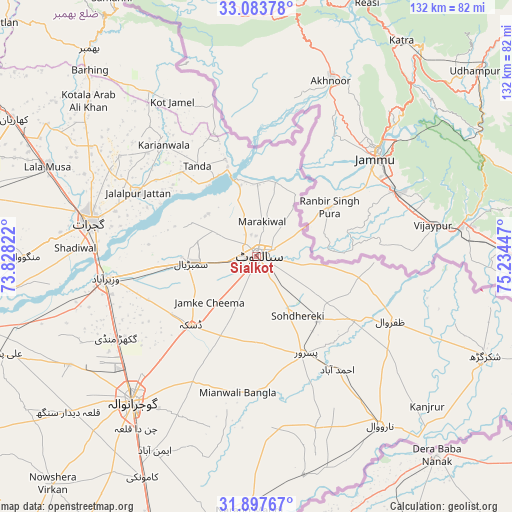
Sialkot GPS coordinates[2]
32° 29' 33.648" North, 74° 31' 52.824" East
| Map corner | latitude | longitude |
|---|---|---|
| Upper-left | 33.08378°, | 73.82822° |
| Center: | 32.49268°, | 74.53134° |
| Lower-right: | 31.89767°, | 75.23447° |
| Map W x H: | 131.9×131.9 km | = 82×82mi |
| max Lat: | 36.32162° ⇑24.6% North |
| Sialkot: | 32.49268° |
| min Lat: | ⇓75.4% South 24.14422° |
| min Long | Sialkot | max Long |
| 61.74573° | 74.53134° | 75.63372° |
| W 96.6%⇐ | ⇒3.4% E |
Elevation
Elevation of Sialkot is 250 m = 820 ft, and this is 95 m = 312 ft below average elevation for this country.
| Max E: |
2732 m = 8963 ft | 28.7% |
| Avg. | 345 m = 1132 ft | |
| Sialkot | 250 m = 820 ft | |
Min E: |
3 m = 10 ft | 71.3% |
See also: Sialkot elevation on elevation.city.
Geographical zone
Sialkot is located in North temperate zone (between Tropic of Cancer and the Arctic Circle). Distance of this Northern Tropic circle is 1006.9 km =625.7 mi to South.| Distance of | km | miles | from Sialkot |
|---|---|---|---|
| North Pole | 6394.2 | 3973.2 | to North |
| Arctic Circle | 3788.3 | 2353.9 | to North |
| Tropic Cancer | 1006.9 | 625.7 | to South |
| Equator | 3612.8 | 2244.9 | to South |


Nearby cities:
15 places around Sialkot: (largest is in red/bold)
• Begowala
25.4 km =15.8 mi,  256°
256°
• Bhopalwala
17.2 km =10.7 mi,  246°
246°
• Chawinda
23.2 km =14.4 mi,  135°
135°
• Daska Kalan
25.3 km =15.7 mi,  222°
222°
• Dhaunkal
38.2 km =23.7 mi, 255°
• Hadali
16.8 km =10.4 mi,  12°
12°
• Jalalpur Jattan
34.7 km =21.6 mi,  298°
298°
• Kalaswala
34.3 km =21.3 mi,  161°
161°
• Kot Ghulam Muhammad
17.8 km =11.1 mi,  175°
175°
• Kot Rajkour
12.8 km =8 mi,  134°
134°
• Kotli Loharan
11.2 km =7 mi,  342°
342°
• Pasrur
28.4 km =17.6 mi,  154°
154°
• Sambrial
16.8 km =10.4 mi, 264°
• Sodhri
32.9 km =20.4 mi, 264°
• Surkhpur
26.3 km =16.3 mi, 342°
Sources, notices
• [Note1] Compared only with cities in Pakistan existing in our database
• [Src1] Map data: © OpenStreetMap contributors (CC-BY-SA)
• [Src2] Other city data from geonames.org with taken over terms of usage.
• [Src3] Geographical zone / Annual Mean Temperature by Robert A. Rohde @ Wikipedia
