Kot Rajkour geodata
Kot Rajkour (Punjab) is a populated place; located in Pakistan in Asia/Karachi (GMT+5) time zone. With population of 1,542 people, there are 403 cities with bigger population in this country. Compared to other cities in Pakistan, 73.4% of cities are located further ↓South; 97.5% of cities are located further ←West and 70.9% of cities have lower elevation than Kot Rajkour. Note1


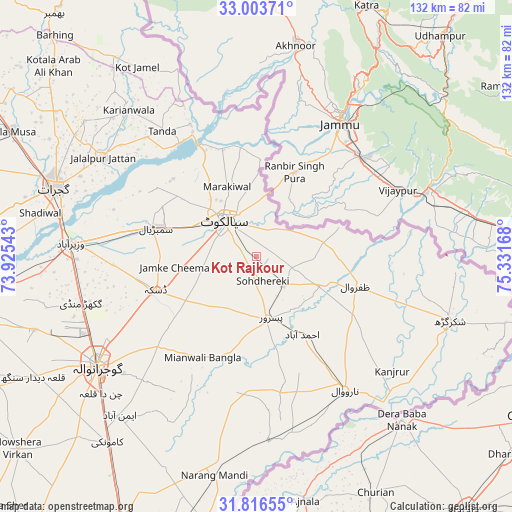
Kot Rajkour GPS coordinates[2]
32° 24' 43.488" North, 74° 37' 42.78" East
| Map corner | latitude | longitude |
|---|---|---|
| Upper-left | 33.00371°, | 73.92543° |
| Center: | 32.41208°, | 74.62855° |
| Lower-right: | 31.81655°, | 75.33168° |
| Map W x H: | 132×132 km | = 82×82mi |
| max Lat: | 36.32162° ⇑26.6% North |
| Kot Rajkour: | 32.41208° |
| min Lat: | ⇓73.4% South 24.14422° |
| min Long | Kot Rajkour | max Long |
| 61.74573° | 74.62855° | 75.63372° |
| W 97.5%⇐ | ⇒2.5% E |
Elevation
Elevation of Kot Rajkour is 248 m = 814 ft, and this is 97 m = 318 ft below average elevation for this country.
| Max E: |
2732 m = 8963 ft | 29.1% |
| Avg. | 345 m = 1132 ft | |
| Kot Rajkour | 248 m = 814 ft | |
Min E: |
3 m = 10 ft | 70.9% |
See also: Pakistan elevation on elevation.city.
Geographical zone
Kot Rajkour is located in North temperate zone (between Tropic of Cancer and the Arctic Circle). Distance of this Northern Tropic circle is 998 km =620.1 mi to South.| Distance of | km | miles | from Kot Rajkour |
|---|---|---|---|
| North Pole | 6403.2 | 3978.8 | to North |
| Arctic Circle | 3797.3 | 2359.5 | to North |
| Tropic Cancer | 998 | 620.1 | to South |
| Equator | 3603.9 | 2239.4 | to South |


Nearby cities:
15 places around Kot Rajkour: (largest is in red/bold)
• Begowala
34 km =21.1 mi,  274°
274°
• Bhopalwala
25 km =15.5 mi, 274°
• Chawinda
10.4 km =6.5 mi,  136°
136°
• Daska Kalan
27.9 km =17.3 mi,  249°
249°
• Hadali
26 km =16.2 mi,  347°
347°
• Kalaswala
23.6 km =14.7 mi,  175°
175°
• Kot Ghulam Muhammad
11.7 km =7.3 mi,  221°
221°
• Kotli Loharan
23.3 km =14.5 mi,  327°
327°
• Narowal
41.4 km =25.7 mi,  146°
146°
• Pasrur
16.9 km =10.5 mi,  168°
168°
• Sambrial
26.9 km =16.7 mi,  285°
285°
• Sialkot
12.8 km =8 mi,  314°
314°
• Sodhri
42.3 km =26.3 mi,  277°
277°
• Surkhpur
38 km =23.6 mi, 333°
• Zafarwal
26.6 km =16.5 mi,  106°
106°
Sources, notices
• [Note1] Compared only with cities in Pakistan existing in our database
• [Src1] Map data: © OpenStreetMap contributors (CC-BY-SA)
• [Src2] Other city data from geonames.org with taken over terms of usage.
• [Src3] Geographical zone / Annual Mean Temperature by Robert A. Rohde @ Wikipedia
