Kalaswala geodata
Kalaswala (Punjab) is a populated place; located in Pakistan in Asia/Karachi (GMT+5) time zone. With population of 12,576 people, there are 335 cities with bigger population in this country. Compared to other cities in Pakistan, 68.8% of cities are located further ↓South; 97.7% of cities are located further ←West and 69.8% of cities have lower elevation than Kalaswala. Note1


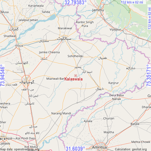
Kalaswala GPS coordinates[2]
32° 12' 2.916" North, 74° 38' 54.888" East
| Map corner | latitude | longitude |
|---|---|---|
| Upper-left | 32.79383°, | 73.94546° |
| Center: | 32.20081°, | 74.64858° |
| Lower-right: | 31.6039°, | 75.35171° |
| Map W x H: | 132.3×132.3 km | = 82.2×82.2mi |
| max Lat: | 36.32162° ⇑31.2% North |
| Kalaswala: | 32.20081° |
| min Lat: | ⇓68.8% South 24.14422° |
| min Long | Kalaswala | max Long |
| 61.74573° | 74.64858° | 75.63372° |
| W 97.7%⇐ | ⇒2.3% E |
Elevation
Elevation of Kalaswala is 240 m = 787 ft, and this is 105 m = 344 ft below average elevation for this country.
| Max E: |
2732 m = 8963 ft | 30.2% |
| Avg. | 345 m = 1132 ft | |
| Kalaswala | 240 m = 787 ft | |
Min E: |
3 m = 10 ft | 69.8% |
See also: Pakistan elevation on elevation.city.
Geographical zone
Kalaswala is located in North temperate zone (between Tropic of Cancer and the Arctic Circle). Distance of this Northern Tropic circle is 974.5 km =605.5 mi to South.| Distance of | km | miles | from Kalaswala |
|---|---|---|---|
| North Pole | 6426.7 | 3993.4 | to North |
| Arctic Circle | 3820.8 | 2374.1 | to North |
| Tropic Cancer | 974.5 | 605.5 | to South |
| Equator | 3580.4 | 2224.8 | to South |


Nearby cities:
15 places around Kalaswala: (largest is in red/bold)
• Baddomalhi
23.4 km =14.5 mi,  176°
176°
• Bhopalwala
36.9 km =22.9 mi,  313°
313°
• Chawinda
16.8 km =10.4 mi,  18°
18°
• Daska Kalan
31.2 km =19.4 mi,  296°
296°
• Eminabad
40.6 km =25.2 mi,  244°
244°
• Fazilpur
39.4 km =24.5 mi,  93°
93°
• Gujranwala
43.7 km =27.2 mi,  263°
263°
• Kot Ghulam Muhammad
17.5 km =10.9 mi,  326°
326°
• Kot Rajkour
23.6 km =14.7 mi,  355°
355°
• Narang Mandi
35.3 km =21.9 mi,  200°
200°
• Narowal
23.8 km =14.8 mi,  117°
117°
• Pasrur
7 km =4.3 mi,  11°
11°
• Sambrial
41.5 km =25.8 mi,  318°
318°
• Sialkot
34.3 km =21.3 mi,  341°
341°
• Zafarwal
28.5 km =17.7 mi,  55°
55°
Sources, notices
• [Note1] Compared only with cities in Pakistan existing in our database
• [Src1] Map data: © OpenStreetMap contributors (CC-BY-SA)
• [Src2] Other city data from geonames.org with taken over terms of usage.
• [Src3] Geographical zone / Annual Mean Temperature by Robert A. Rohde @ Wikipedia
