Jalalpur Jattan geodata
Jalalpur Jattan (Punjab) is a populated place; located in Pakistan in Asia/Karachi (GMT+5) time zone. With population of 93,883 people, there are 71 cities with bigger population in this country. Compared to other cities in Pakistan, 78.1% of cities are located further ↓South; 92.8% of cities are located further ←West and 71.3% of cities have lower elevation than Jalalpur Jattan. Note1


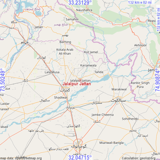
Jalalpur Jattan GPS coordinates[2]
32° 38' 28.248" North, 74° 12' 20.196" East
| Map corner | latitude | longitude |
|---|---|---|
| Upper-left | 33.23129°, | 73.50249° |
| Center: | 32.64118°, | 74.20561° |
| Lower-right: | 32.04715°, | 74.90874° |
| Map W x H: | 131.7×131.7 km | = 81.8×81.8mi |
| max Lat: | 36.32162° ⇑21.9% North |
| Jalalpur Jattan: | 32.64118° |
| min Lat: | ⇓78.1% South 24.14422° |
| min Long | Jalalpur Jattan | max Long |
| 61.74573° | 74.20561° | 75.63372° |
| W 92.8%⇐ | ⇒7.2% E |
Elevation
Elevation of Jalalpur Jattan is 250 m = 820 ft, and this is 95 m = 312 ft below average elevation for this country.
| Max E: |
2732 m = 8963 ft | 28.7% |
| Avg. | 345 m = 1132 ft | |
| Jalalpur Jattan | 250 m = 820 ft | |
Min E: |
3 m = 10 ft | 71.3% |
See also: Jalalpur Jattan elevation on elevation.city.
Geographical zone
Jalalpur Jattan is located in North temperate zone (between Tropic of Cancer and the Arctic Circle). Distance of this Northern Tropic circle is 1023.4 km =635.9 mi to South.| Distance of | km | miles | from Jalalpur Jattan |
|---|---|---|---|
| North Pole | 6377.7 | 3962.9 | to North |
| Arctic Circle | 3771.8 | 2343.7 | to North |
| Tropic Cancer | 1023.4 | 635.9 | to South |
| Equator | 3629.4 | 2255.2 | to South |


Nearby cities:
15 places around Jalalpur Jattan: (largest is in red/bold)
• Begowala
23.3 km =14.5 mi,  165°
165°
• Bhopalwala
27.8 km =17.3 mi,  147°
147°
• Daska Kalan
37.8 km =23.5 mi,  158°
158°
• Dhaunkal
26.9 km =16.7 mi,  193°
193°
• Gujrat
14.3 km =8.9 mi,  238°
238°
• Hadali
34 km =21.1 mi,  90°
90°
• Kharian
35.6 km =22.1 mi,  303°
303°
• Kotli Loharan
27.7 km =17.2 mi,  102°
102°
• Kunjah
24.9 km =15.5 mi, 240°
• Lala Musa
24.2 km =15 mi,  286°
286°
• Sambrial
22.8 km =14.2 mi,  142°
142°
• Sialkot
34.7 km =21.6 mi,  118°
118°
• Sodhri
20 km =12.4 mi, 186°
• Surkhpur
24.2 km =15 mi,  69°
69°
• Wazirabad
23.4 km =14.5 mi,  200°
200°
Sources, notices
• [Note1] Compared only with cities in Pakistan existing in our database
• [Src1] Map data: © OpenStreetMap contributors (CC-BY-SA)
• [Src2] Other city data from geonames.org with taken over terms of usage.
• [Src3] Geographical zone / Annual Mean Temperature by Robert A. Rohde @ Wikipedia
