Pasrur geodata
Pasrur (Punjab) is a populated place; located in Pakistan in Asia/Karachi (GMT+5) time zone. With population of 53,364 people, there are 123 cities with bigger population in this country. Compared to other cities in Pakistan, 70% of cities are located further ↓South; 98% of cities are located further ←West and 72% of cities have lower elevation than Pasrur. Note1


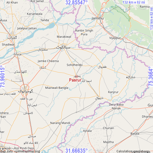
Pasrur GPS coordinates[2]
32° 15' 46.296" North, 74° 39' 47.772" East
| Map corner | latitude | longitude |
|---|---|---|
| Upper-left | 32.85547°, | 73.96015° |
| Center: | 32.26286°, | 74.66327° |
| Lower-right: | 31.66635°, | 75.3664° |
| Map W x H: | 132.2×132.2 km | = 82.1×82.1mi |
| max Lat: | 36.32162° ⇑30% North |
| Pasrur: | 32.26286° |
| min Lat: | ⇓70% South 24.14422° |
| min Long | Pasrur | max Long |
| 61.74573° | 74.66327° | 75.63372° |
| W 98%⇐ | ⇒2% E |
Elevation
Elevation of Pasrur is 251 m = 823 ft, and this is 94 m = 308 ft below average elevation for this country.
| Max E: |
2732 m = 8963 ft | 28% |
| Avg. | 345 m = 1132 ft | |
| Pasrur | 251 m = 823 ft | |
Min E: |
3 m = 10 ft | 72% |
See also: Pasrur elevation on elevation.city.
Geographical zone
Pasrur is located in North temperate zone (between Tropic of Cancer and the Arctic Circle). Distance of this Northern Tropic circle is 981.4 km =609.8 mi to South.| Distance of | km | miles | from Pasrur |
|---|---|---|---|
| North Pole | 6419.8 | 3989.1 | to North |
| Arctic Circle | 3813.9 | 2369.8 | to North |
| Tropic Cancer | 981.4 | 609.8 | to South |
| Equator | 3587.3 | 2229 | to South |


Nearby cities:
15 places around Pasrur: (largest is in red/bold)
• Baddomalhi
30.3 km =18.8 mi,  179°
179°
• Begowala
41.9 km =26 mi,  297°
297°
• Bhopalwala
33.7 km =20.9 mi, 303°
• Chawinda
9.9 km =6.2 mi,  23°
23°
• Daska Kalan
30.2 km =18.8 mi,  283°
283°
• Fazilpur
39.1 km =24.3 mi,  104°
104°
• Kalaswala
7 km =4.3 mi,  191°
191°
• Kot Ghulam Muhammad
13.4 km =8.3 mi,  305°
305°
• Kot Rajkour
16.9 km =10.5 mi,  348°
348°
• Kotli Loharan
39.6 km =24.6 mi,  336°
336°
• Narang Mandi
42.3 km =26.3 mi,  199°
199°
• Narowal
26.6 km =16.5 mi,  132°
132°
• Sambrial
37.7 km =23.4 mi, 309°
• Sialkot
28.4 km =17.6 mi,  334°
334°
• Zafarwal
24 km =14.9 mi,  67°
67°
Sources, notices
• [Note1] Compared only with cities in Pakistan existing in our database
• [Src1] Map data: © OpenStreetMap contributors (CC-BY-SA)
• [Src2] Other city data from geonames.org with taken over terms of usage.
• [Src3] Geographical zone / Annual Mean Temperature by Robert A. Rohde @ Wikipedia
