Jaranwala geodata
Jaranwala (Punjab) is a populated place; located in Pakistan in Asia/Karachi (GMT+5) time zone. With population of 119,785 people, there are 58 cities with bigger population in this country. Compared to other cities in Pakistan, 57.3% of cities are located further ↓South; 80.4% of cities are located further ←West and 55.5% of cities have lower elevation than Jaranwala. Note1


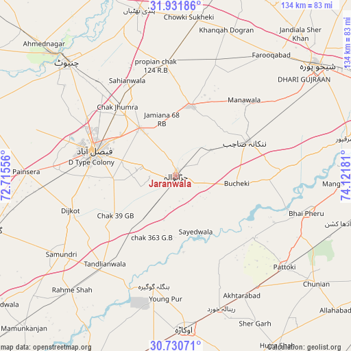
Jaranwala GPS coordinates[2]
31° 19' 59.52" North, 73° 25' 7.248" East
| Map corner | latitude | longitude |
|---|---|---|
| Upper-left | 31.93186°, | 72.71556° |
| Center: | 31.3332°, | 73.41868° |
| Lower-right: | 30.73071°, | 74.12181° |
| Map W x H: | 133.6×133.6 km | = 83×83mi |
| max Lat: | 36.32162° ⇑42.7% North |
| Jaranwala: | 31.3332° |
| min Lat: | ⇓57.3% South 24.14422° |
| min Long | Jaranwala | max Long |
| 61.74573° | 73.41868° | 75.63372° |
| W 80.4%⇐ | ⇒19.6% E |
Elevation
Elevation of Jaranwala is 193 m = 633 ft, and this is 152 m = 499 ft below average elevation for this country.
| Max E: |
2732 m = 8963 ft | 44.5% |
| Avg. | 345 m = 1132 ft | |
| Jaranwala | 193 m = 633 ft | |
Min E: |
3 m = 10 ft | 55.5% |
See also: Jaranwala elevation on elevation.city.
Geographical zone
Jaranwala is located in North temperate zone (between Tropic of Cancer and the Arctic Circle). Distance of this Northern Tropic circle is 878 km =545.6 mi to South.| Distance of | km | miles | from Jaranwala |
|---|---|---|---|
| North Pole | 6523.1 | 4053.3 | to North |
| Arctic Circle | 3917.2 | 2434 | to North |
| Tropic Cancer | 878 | 545.6 | to South |
| Equator | 3483.9 | 2164.8 | to South |


Nearby cities:
15 places around Jaranwala: (largest is in red/bold)
• Chak Five Hundred Seventy-five
45.5 km =28.3 mi,  58°
58°
• Chak Jhumra
34.4 km =21.4 mi,  319°
319°
• Dijkot
42.2 km =26.2 mi,  252°
252°
• Faisalabad
32.5 km =20.2 mi,  286°
286°
• Khurrianwala
23.4 km =14.5 mi, 322°
• Mananwala
38.2 km =23.7 mi,  42°
42°
• Mianke Mor
52.4 km =32.6 mi,  106°
106°
• Mustafābād
49.6 km =30.8 mi,  171°
171°
• Nankana Sahib
30.3 km =18.8 mi, 64°
• Okara
58.2 km =36.2 mi,  176°
176°
• Pattoki
54 km =33.6 mi,  130°
130°
• Renala Khurd
53.4 km =33.2 mi,  161°
161°
• Sangla Hill
42.8 km =26.6 mi,  355°
355°
• Shahkot
27.2 km =16.9 mi,  13°
13°
• Tandlianwala
43 km =26.7 mi,  219°
219°
Sources, notices
• [Note1] Compared only with cities in Pakistan existing in our database
• [Src1] Map data: © OpenStreetMap contributors (CC-BY-SA)
• [Src2] Other city data from geonames.org with taken over terms of usage.
• [Src3] Geographical zone / Annual Mean Temperature by Robert A. Rohde @ Wikipedia
