Chenab Nagar geodata
Chenab Nagar (Punjab) is a populated place; located in Pakistan in Asia/Karachi (GMT+5) time zone. With population of 70,000 people, there are 96 cities with bigger population in this country. Compared to other cities in Pakistan, 61.6% of cities are located further ↓South; 70.7% of cities are located further ←West and 51.9% of cities have lower elevation than Chenab Nagar. Note1


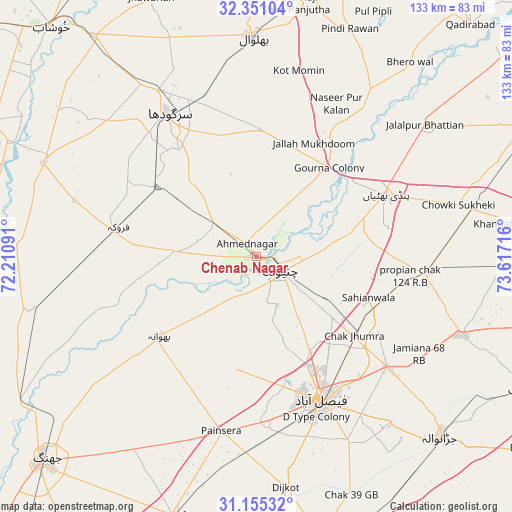
Chenab Nagar GPS coordinates[2]
31° 45' 18.396" North, 72° 54' 50.508" East
| Map corner | latitude | longitude |
|---|---|---|
| Upper-left | 32.35104°, | 72.21091° |
| Center: | 31.75511°, | 72.91403° |
| Lower-right: | 31.15532°, | 73.61716° |
| Map W x H: | 133×133 km | = 82.6×82.6mi |
| max Lat: | 36.32162° ⇑38.4% North |
| Chenab Nagar: | 31.75511° |
| min Lat: | ⇓61.6% South 24.14422° |
| min Long | Chenab Nagar | max Long |
| 61.74573° | 72.91403° | 75.63372° |
| W 70.7%⇐ | ⇒29.3% E |
Elevation
Elevation of Chenab Nagar is 183 m = 600 ft, and this is 162 m = 531 ft below average elevation for this country.
| Max E: |
2732 m = 8963 ft | 48.1% |
| Avg. | 345 m = 1132 ft | |
| Chenab Nagar | 183 m = 600 ft | |
Min E: |
3 m = 10 ft | 51.9% |
See also: Chenab Nagar elevation on elevation.city.
Geographical zone
Chenab Nagar is located in North temperate zone (between Tropic of Cancer and the Arctic Circle). Distance of this Northern Tropic circle is 924.9 km =574.7 mi to South.| Distance of | km | miles | from Chenab Nagar |
|---|---|---|---|
| North Pole | 6476.2 | 4024.1 | to North |
| Arctic Circle | 3870.3 | 2404.9 | to North |
| Tropic Cancer | 924.9 | 574.7 | to South |
| Equator | 3530.8 | 2193.9 | to South |


Nearby cities:
15 places around Chenab Nagar: (largest is in red/bold)
• Bhalwal
56.8 km =35.3 mi,  358°
358°
• Bhawana
32.5 km =20.2 mi,  230°
230°
• Chak Jhumra
32.9 km =20.4 mi,  129°
129°
• Chiniot
7.2 km =4.5 mi,  122°
122°
• Faisalabad
41.3 km =25.7 mi,  156°
156°
• Faruka
49.5 km =30.8 mi,  287°
287°
• Khurrianwala
43.9 km =27.3 mi, 130°
• Kot Mumin
49.4 km =30.7 mi,  12°
12°
• Lalian
13.2 km =8.2 mi,  305°
305°
• Liliani
50 km =31.1 mi,  4°
4°
• Mangla
52.6 km =32.7 mi, 286°
• Pindi Bhattian
37.5 km =23.3 mi,  64°
64°
• Sangla Hill
44.6 km =27.7 mi,  95°
95°
• Sargodha
43.2 km =26.8 mi,  328°
328°
• Sillanwali
36.1 km =22.4 mi,  282°
282°
Sources, notices
• [Note1] Compared only with cities in Pakistan existing in our database
• [Src1] Map data: © OpenStreetMap contributors (CC-BY-SA)
• [Src2] Other city data from geonames.org with taken over terms of usage.
• [Src3] Geographical zone / Annual Mean Temperature by Robert A. Rohde @ Wikipedia
