Thul geodata
Thul (Sindh) is a populated place; located in Pakistan in Asia/Karachi (GMT+5) time zone. With population of 34,472 people, there are 183 cities with bigger population in this country. Compared to other cities in Pakistan, 70.9% of cities are located further ↑North; 73.1% of cities are located further →East and 74.7% of cities have higher elevation than Thul. Note1


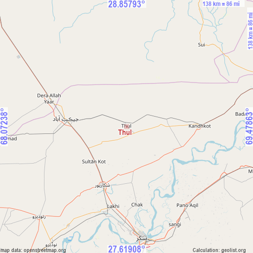
Thul GPS coordinates[2]
28° 14' 25.08" North, 68° 46' 31.8" East
| Map corner | latitude | longitude |
|---|---|---|
| Upper-left | 28.85793°, | 68.07238° |
| Center: | 28.2403°, | 68.7755° |
| Lower-right: | 27.61908°, | 69.47863° |
| Map W x H: | 137.7×137.7 km | = 85.6×85.6mi |
| max Lat: | 36.32162° ⇑70.9% North |
| Thul: | 28.2403° |
| min Lat: | ⇓29.1% South 24.14422° |
| min Long | Thul | max Long |
| 61.74573° | 68.7755° | 75.63372° |
| W 26.9%⇐ | ⇒73.1% E |
Elevation
Elevation of Thul is 64 m = 210 ft, and this is 281 m = 922 ft below average elevation for this country.
| Max E: |
2732 m = 8963 ft | 74.7% |
| Avg. | 345 m = 1132 ft | |
| Thul | 64 m = 210 ft | |
Min E: |
3 m = 10 ft | 25.3% |
See also: Pakistan elevation on elevation.city.
Geographical zone
Thul is located in North temperate zone (between Tropic of Cancer and the Arctic Circle). Distance of this Northern Tropic circle is 534.1 km =331.9 mi to South.| Distance of | km | miles | from Thul |
|---|---|---|---|
| North Pole | 6867 | 4267 | to North |
| Arctic Circle | 4261.1 | 2647.7 | to North |
| Tropic Cancer | 534.1 | 331.9 | to South |
| Equator | 3140 | 1951.1 | to South |


Nearby cities:
15 places around Thul: (largest is in red/bold)
• Bagarji
54.1 km =33.6 mi,  181°
181°
• Chak
42.8 km =26.6 mi,  172°
172°
• Dera Allahyar
44.1 km =27.4 mi,  289°
289°
• Garhiyasin
45.2 km =28.1 mi,  214°
214°
• Ghauspur
32.1 km =19.9 mi,  110°
110°
• Ghotki
59.1 km =36.7 mi,  116°
116°
• Jacobabad
33.4 km =20.8 mi,  277°
277°
• Kandhkot
39.6 km =24.6 mi,  89°
89°
• Lakhi
44.2 km =27.5 mi,  189°
189°
• Pano Aqil
53.9 km =33.5 mi,  142°
142°
• Rustam
30.5 km =19 mi, 174°
• Shikarpur
34.4 km =21.4 mi,  203°
203°
• Sohbatpur
38.6 km =24 mi,  323°
323°
• Sukkur
60.3 km =37.5 mi, 172°
• Tangwani
22.2 km =13.8 mi,  78°
78°
Sources, notices
• [Note1] Compared only with cities in Pakistan existing in our database
• [Src1] Map data: © OpenStreetMap contributors (CC-BY-SA)
• [Src2] Other city data from geonames.org with taken over terms of usage.
• [Src3] Geographical zone / Annual Mean Temperature by Robert A. Rohde @ Wikipedia
