Shikarpur geodata
Shikarpur (Sindh) is a seat of a second-order administrative division; located in Pakistan in Asia/Karachi (GMT+5) time zone. With population of 156,901 people, there are 41 cities with bigger population in this country. Compared to other cities in Pakistan, 73.4% of cities are located further ↑North; 75.4% of cities are located further →East and 73.1% of cities have higher elevation than Shikarpur. Note1


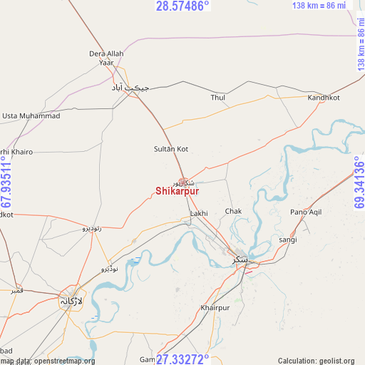
Shikarpur GPS coordinates[2]
27° 57' 20.088" North, 68° 38' 17.628" East
| Map corner | latitude | longitude |
|---|---|---|
| Upper-left | 28.57486°, | 67.93511° |
| Center: | 27.95558°, | 68.63823° |
| Lower-right: | 27.33272°, | 69.34136° |
| Map W x H: | 138.1×138.1 km | = 85.8×85.8mi |
| max Lat: | 36.32162° ⇑73.4% North |
| Shikarpur: | 27.95558° |
| min Lat: | ⇓26.6% South 24.14422° |
| min Long | Shikarpur | max Long |
| 61.74573° | 68.63823° | 75.63372° |
| W 24.6%⇐ | ⇒75.4% E |
Elevation
Elevation of Shikarpur is 71 m = 233 ft, and this is 274 m = 899 ft below average elevation for this country.
| Max E: |
2732 m = 8963 ft | 73.1% |
| Avg. | 345 m = 1132 ft | |
| Shikarpur | 71 m = 233 ft | |
Min E: |
3 m = 10 ft | 26.9% |
See also: Shikarpur elevation on elevation.city.
Geographical zone
Shikarpur is located in North temperate zone (between Tropic of Cancer and the Arctic Circle). Distance of this Northern Tropic circle is 502.5 km =312.2 mi to South.| Distance of | km | miles | from Shikarpur |
|---|---|---|---|
| North Pole | 6898.7 | 4286.7 | to North |
| Arctic Circle | 4292.8 | 2667.4 | to North |
| Tropic Cancer | 502.5 | 312.2 | to South |
| Equator | 3108.4 | 1931.5 | to South |


Nearby cities:
15 places around Shikarpur: (largest is in red/bold)
• Bagarji
25.3 km =15.7 mi,  152°
152°
• Chak
22 km =13.7 mi,  119°
119°
• Garhiyasin
13.5 km =8.4 mi,  246°
246°
• Ghauspur
48.1 km =29.9 mi,  64°
64°
• Jacobabad
41.3 km =25.7 mi,  331°
331°
• Lakhi
13.3 km =8.3 mi, 153°
• Madeji
29 km =18 mi,  219°
219°
• Naudero
42.1 km =26.2 mi, 220°
• Pano Aqil
47.8 km =29.7 mi,  103°
103°
• Pir Jo Goth
40.5 km =25.2 mi,  182°
182°
• Ratodero
38.3 km =23.8 mi,  243°
243°
• Rohri
38.7 km =24 mi,  139°
139°
• Rustam
16.3 km =10.1 mi,  85°
85°
• Sukkur
35.5 km =22.1 mi, 142°
• Thul
34.4 km =21.4 mi,  23°
23°
Sources, notices
• [Note1] Compared only with cities in Pakistan existing in our database
• [Src1] Map data: © OpenStreetMap contributors (CC-BY-SA)
• [Src2] Other city data from geonames.org with taken over terms of usage.
• [Src3] Geographical zone / Annual Mean Temperature by Robert A. Rohde @ Wikipedia
