Phalia geodata
Phalia (Punjab) is a populated place; located in Pakistan in Asia/Karachi (GMT+5) time zone. With population of 24,789 people, there are 242 cities with bigger population in this country. Compared to other cities in Pakistan, 73.8% of cities are located further ↓South; 82.6% of cities are located further ←West and 62.1% of cities have lower elevation than Phalia. Note1


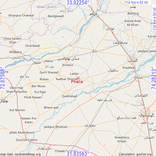
Phalia GPS coordinates[2]
32° 25' 51.744" North, 73° 34' 44.4" East
| Map corner | latitude | longitude |
|---|---|---|
| Upper-left | 33.02254°, | 72.87588° |
| Center: | 32.43104°, | 73.579° |
| Lower-right: | 31.83563°, | 74.28213° |
| Map W x H: | 132×132 km | = 82×82mi |
| max Lat: | 36.32162° ⇑26.2% North |
| Phalia: | 32.43104° |
| min Lat: | ⇓73.8% South 24.14422° |
| min Long | Phalia | max Long |
| 61.74573° | 73.579° | 75.63372° |
| W 82.6%⇐ | ⇒17.4% E |
Elevation
Elevation of Phalia is 211 m = 692 ft, and this is 134 m = 440 ft below average elevation for this country.
| Max E: |
2732 m = 8963 ft | 37.9% |
| Avg. | 345 m = 1132 ft | |
| Phalia | 211 m = 692 ft | |
Min E: |
3 m = 10 ft | 62.1% |
See also: Pakistan elevation on elevation.city.
Geographical zone
Phalia is located in North temperate zone (between Tropic of Cancer and the Arctic Circle). Distance of this Northern Tropic circle is 1000.1 km =621.4 mi to South.| Distance of | km | miles | from Phalia |
|---|---|---|---|
| North Pole | 6401.1 | 3977.5 | to North |
| Arctic Circle | 3795.2 | 2358.2 | to North |
| Tropic Cancer | 1000.1 | 621.4 | to South |
| Equator | 3606 | 2240.7 | to South |


Nearby cities:
15 places around Phalia: (largest is in red/bold)
• Dhaunkal
52.5 km =32.6 mi,  93°
93°
• Dinga
26.8 km =16.7 mi,  29°
29°
• Gujrat
49.2 km =30.6 mi,  71°
71°
• Hafizabad
41.3 km =25.7 mi,  165°
165°
• Kaleke Mandi
50.6 km =31.4 mi,  177°
177°
• Kharian
51.6 km =32.1 mi, 33°
• Kunjah
38.7 km =24 mi, 73°
• Lala Musa
46.5 km =28.9 mi,  49°
49°
• Malakwal
37 km =23 mi,  291°
291°
• Malakwal City
37.1 km =23.1 mi, 291°
• Mandi Bahauddin
19.2 km =11.9 mi,  334°
334°
• Mehmand Chak
45.5 km =28.3 mi, 30°
• Pind Dadan Khan
53 km =32.9 mi, 289°
• Rasulnagar
22.1 km =13.7 mi,  121°
121°
• Wazirabad
50.8 km =31.6 mi, 88°
Sources, notices
• [Note1] Compared only with cities in Pakistan existing in our database
• [Src1] Map data: © OpenStreetMap contributors (CC-BY-SA)
• [Src2] Other city data from geonames.org with taken over terms of usage.
• [Src3] Geographical zone / Annual Mean Temperature by Robert A. Rohde @ Wikipedia
