Dinga geodata
Dinga (Punjab) is a populated place; located in Pakistan in Asia/Karachi (GMT+5) time zone. With population of 39,784 people, there are 156 cities with bigger population in this country. Compared to other cities in Pakistan, 77.9% of cities are located further ↓South; 84.7% of cities are located further ←West and 66.6% of cities have lower elevation than Dinga. Note1


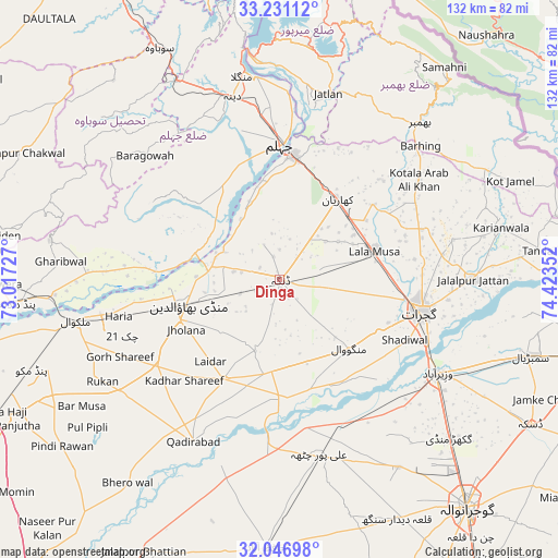
Dinga GPS coordinates[2]
32° 38' 27.636" North, 73° 43' 13.404" East
| Map corner | latitude | longitude |
|---|---|---|
| Upper-left | 33.23112°, | 73.01727° |
| Center: | 32.64101°, | 73.72039° |
| Lower-right: | 32.04698°, | 74.42352° |
| Map W x H: | 131.7×131.7 km | = 81.8×81.8mi |
| max Lat: | 36.32162° ⇑22.1% North |
| Dinga: | 32.64101° |
| min Lat: | ⇓77.9% South 24.14422° |
| min Long | Dinga | max Long |
| 61.74573° | 73.72039° | 75.63372° |
| W 84.7%⇐ | ⇒15.3% E |
Elevation
Elevation of Dinga is 229 m = 751 ft, and this is 116 m = 381 ft below average elevation for this country.
| Max E: |
2732 m = 8963 ft | 33.4% |
| Avg. | 345 m = 1132 ft | |
| Dinga | 229 m = 751 ft | |
Min E: |
3 m = 10 ft | 66.6% |
See also: Pakistan elevation on elevation.city.
Geographical zone
Dinga is located in North temperate zone (between Tropic of Cancer and the Arctic Circle). Distance of this Northern Tropic circle is 1023.4 km =635.9 mi to South.| Distance of | km | miles | from Dinga |
|---|---|---|---|
| North Pole | 6377.7 | 3962.9 | to North |
| Arctic Circle | 3771.8 | 2343.7 | to North |
| Tropic Cancer | 1023.4 | 635.9 | to South |
| Equator | 3629.3 | 2255.1 | to South |


Nearby cities:
15 places around Dinga: (largest is in red/bold)
• Dhaunkal
47 km =29.2 mi,  123°
123°
• Gujrat
34.1 km =21.2 mi,  102°
102°
• Jalalpur Jattan
45.4 km =28.2 mi,  89°
89°
• Jhelum
32.6 km =20.3 mi,  1°
1°
• Kharian
24.9 km =15.5 mi,  38°
38°
• Kunjah
26.9 km =16.7 mi, 117°
• Lala Musa
23.2 km =14.4 mi,  73°
73°
• Malakwal
48.5 km =30.1 mi,  258°
258°
• Mandi Bahauddin
22.3 km =13.9 mi,  254°
254°
• Mehmand Chak
18.7 km =11.6 mi,  30°
30°
• Phalia
26.8 km =16.7 mi,  209°
209°
• Rasulnagar
35.3 km =21.9 mi,  170°
170°
• Sarai Alamgir
29.5 km =18.3 mi,  6°
6°
• Sodhri
47.6 km =29.6 mi,  114°
114°
• Wazirabad
43.4 km =27 mi, 120°
Sources, notices
• [Note1] Compared only with cities in Pakistan existing in our database
• [Src1] Map data: © OpenStreetMap contributors (CC-BY-SA)
• [Src2] Other city data from geonames.org with taken over terms of usage.
• [Src3] Geographical zone / Annual Mean Temperature by Robert A. Rohde @ Wikipedia
