Lala Musa geodata
Lala Musa (Punjab) is a populated place; located in Pakistan in Asia/Karachi (GMT+5) time zone. With population of 65,197 people, there are 109 cities with bigger population in this country. Compared to other cities in Pakistan, 79% of cities are located further ↓South; 89.2% of cities are located further ←West and 72.5% of cities have lower elevation than Lala Musa. Note1


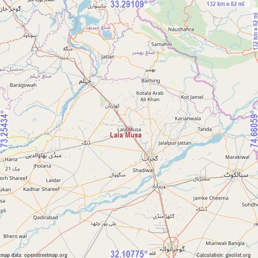
Lala Musa GPS coordinates[2]
32° 42' 4.968" North, 73° 57' 26.856" East
| Map corner | latitude | longitude |
|---|---|---|
| Upper-left | 33.29109°, | 73.25434° |
| Center: | 32.70138°, | 73.95746° |
| Lower-right: | 32.10775°, | 74.66059° |
| Map W x H: | 131.6×131.6 km | = 81.8×81.8mi |
| max Lat: | 36.32162° ⇑21% North |
| Lala Musa: | 32.70138° |
| min Lat: | ⇓79% South 24.14422° |
| min Long | Lala Musa | max Long |
| 61.74573° | 73.95746° | 75.63372° |
| W 89.2%⇐ | ⇒10.8% E |
Elevation
Elevation of Lala Musa is 258 m = 846 ft, and this is 87 m = 285 ft below average elevation for this country.
| Max E: |
2732 m = 8963 ft | 27.5% |
| Avg. | 345 m = 1132 ft | |
| Lala Musa | 258 m = 846 ft | |
Min E: |
3 m = 10 ft | 72.5% |
See also: Lala Musa elevation on elevation.city.
Geographical zone
Lala Musa is located in North temperate zone (between Tropic of Cancer and the Arctic Circle). Distance of this Northern Tropic circle is 1030.1 km =640.1 mi to South.| Distance of | km | miles | from Lala Musa |
|---|---|---|---|
| North Pole | 6371 | 3958.8 | to North |
| Arctic Circle | 3765.1 | 2339.5 | to North |
| Tropic Cancer | 1030.1 | 640.1 | to South |
| Equator | 3636.1 | 2259.4 | to South |


Nearby cities:
15 places around Lala Musa: (largest is in red/bold)
• Begowala
41.3 km =25.7 mi,  135°
135°
• Bhimbar
32.4 km =20.1 mi,  20°
20°
• Dhaunkal
36.9 km =22.9 mi,  152°
152°
• Dinga
23.2 km =14.4 mi,  253°
253°
• Gujrat
17.9 km =11.1 mi, 142°
• Jalalpur Jattan
24.2 km =15 mi,  106°
106°
• Jhelum
33.5 km =20.8 mi,  320°
320°
• Kharian
14.4 km =8.9 mi,  332°
332°
• Kunjah
19.1 km =11.9 mi,  175°
175°
• Mehmand Chak
15.6 km =9.7 mi,  306°
306°
• Rasulnagar
44.7 km =27.8 mi,  201°
201°
• Sambrial
44.6 km =27.7 mi,  123°
123°
• Sarai Alamgir
29.5 km =18.3 mi, 320°
• Sodhri
33.9 km =21.1 mi, 141°
• Wazirabad
32.5 km =20.2 mi, 152°
Sources, notices
• [Note1] Compared only with cities in Pakistan existing in our database
• [Src1] Map data: © OpenStreetMap contributors (CC-BY-SA)
• [Src2] Other city data from geonames.org with taken over terms of usage.
• [Src3] Geographical zone / Annual Mean Temperature by Robert A. Rohde @ Wikipedia
