Gujrat geodata
Gujrat (Punjab) is a seat of a second-order administrative division; located in Pakistan in Asia/Karachi (GMT+5) time zone. With population of 301,506 people, there are 22 cities with bigger population in this country. Compared to other cities in Pakistan, 76.3% of cities are located further ↓South; 90.3% of cities are located further ←West and 68.6% of cities have lower elevation than Gujrat. Note1


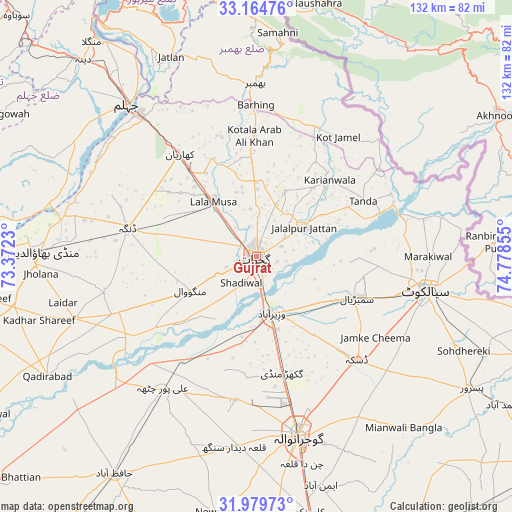
Gujrat GPS coordinates[2]
32° 34' 27.12" North, 74° 4' 31.512" East
| Map corner | latitude | longitude |
|---|---|---|
| Upper-left | 33.16476°, | 73.3723° |
| Center: | 32.5742°, | 74.07542° |
| Lower-right: | 31.97973°, | 74.77855° |
| Map W x H: | 131.8×131.8 km | = 81.9×81.9mi |
| max Lat: | 36.32162° ⇑23.7% North |
| Gujrat: | 32.5742° |
| min Lat: | ⇓76.3% South 24.14422° |
| min Long | Gujrat | max Long |
| 61.74573° | 74.07542° | 75.63372° |
| W 90.3%⇐ | ⇒9.7% E |
Elevation
Elevation of Gujrat is 237 m = 778 ft, and this is 108 m = 354 ft below average elevation for this country.
| Max E: |
2732 m = 8963 ft | 31.4% |
| Avg. | 345 m = 1132 ft | |
| Gujrat | 237 m = 778 ft | |
Min E: |
3 m = 10 ft | 68.6% |
See also: Gujrat elevation on elevation.city.
Geographical zone
Gujrat is located in North temperate zone (between Tropic of Cancer and the Arctic Circle). Distance of this Northern Tropic circle is 1016 km =631.3 mi to South.| Distance of | km | miles | from Gujrat |
|---|---|---|---|
| North Pole | 6385.2 | 3967.6 | to North |
| Arctic Circle | 3779.3 | 2348.3 | to North |
| Tropic Cancer | 1016 | 631.3 | to South |
| Equator | 3621.9 | 2250.5 | to South |


Nearby cities:
15 places around Gujrat: (largest is in red/bold)
• Begowala
23.6 km =14.7 mi,  129°
129°
• Bhopalwala
31.4 km =19.5 mi,  120°
120°
• Daska Kalan
37.9 km =23.5 mi,  137°
137°
• Dhaunkal
19.6 km =12.2 mi,  162°
162°
• Dinga
34.1 km =21.2 mi,  282°
282°
• Jalalpur Jattan
14.3 km =8.9 mi,  58°
58°
• Kharian
32.2 km =20 mi,  326°
326°
• Kunjah
10.6 km =6.6 mi,  242°
242°
• Lala Musa
17.9 km =11.1 mi,  322°
322°
• Mehmand Chak
33.3 km =20.7 mi,  314°
314°
• Rasulnagar
38.9 km =24.2 mi,  225°
225°
• Sambrial
28.2 km =17.5 mi,  112°
112°
• Sodhri
16 km =9.9 mi, 141°
• Surkhpur
38.4 km =23.9 mi,  65°
65°
• Wazirabad
15.1 km =9.4 mi, 163°
Sources, notices
• [Note1] Compared only with cities in Pakistan existing in our database
• [Src1] Map data: © OpenStreetMap contributors (CC-BY-SA)
• [Src2] Other city data from geonames.org with taken over terms of usage.
• [Src3] Geographical zone / Annual Mean Temperature by Robert A. Rohde @ Wikipedia
